We are booked on a forest safari with Highland Safaris first thing, so it is up at the crack of dawn. I’ll admit that it was slightly earlier than strictly necessary but we are able to lurk in the car park waiting for them to open. We have been on an excursion with this company before but have decided to do another short trip because we enjoyed it so much the first time. We find our way to the safari centre in the village of Dull without incident. I was amused to learn, on our last visit, that Dull was twinned with a town called Boring in Oregon. Apparently, it is now also paired with Bland in New South Wales! Dull is in fact a corruption of the Gaelic for ‘raised meadow’ and was a seventh century monastic settlement. Our tour guide is Dave and we are accompanied in our land rover by a family with a small boy. Again, I am impressed that a family is introducing their offspring to wildlife. We drive through the beech, birch and larch forest, many people don’t realise that the latter are a needle shedding pine. There are also introduced species of pine and the broom is in full flower.
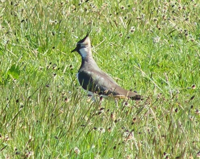
As usual, we are a kiss of death when it comes to wildlife spotting and red squirrels and red deer are both conspicuous by their absence. We don’t see pine marten either. They are much more elusive, so that would have been less likely; although I have seen one on a previous trip to Scotland. We learn that pine marten are useful because they will predate on the grey squirrels but not on the red. There are awe-inspiring views of the Tay valley and we see patches of snow on the heights. Although there are longer rivers, the volume of water in the Tay is greater than any other British river. The first bridge across the Tay was part of General Wade’s bridge and road building scheme, which aided troop movements when he was tasked with suppressing the 1745 Jacobite Rebellion. The town of Aberfeldy grew up round this bridge. It is thought that the Gallic sounding nearby Coshieville may have been so named because the French POWs used by Wade on his road building projects were billeted there.
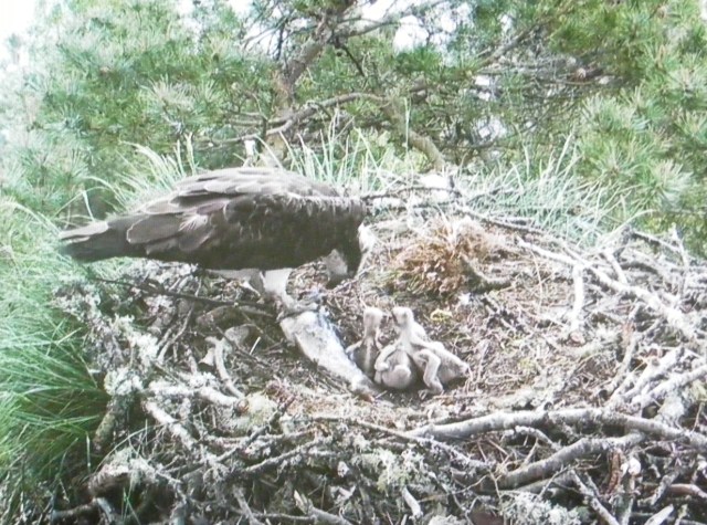
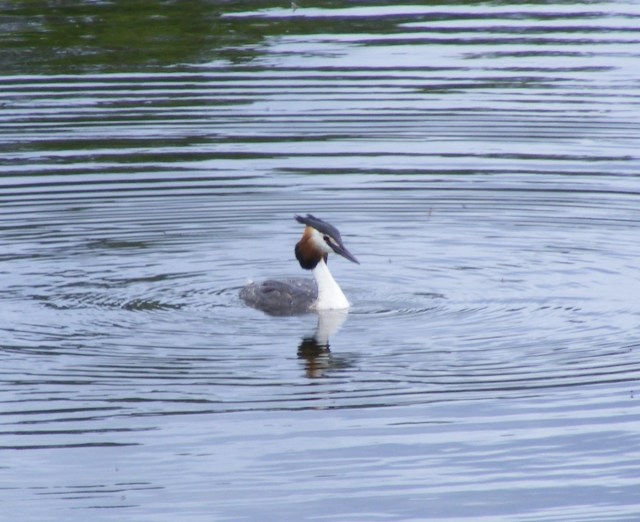
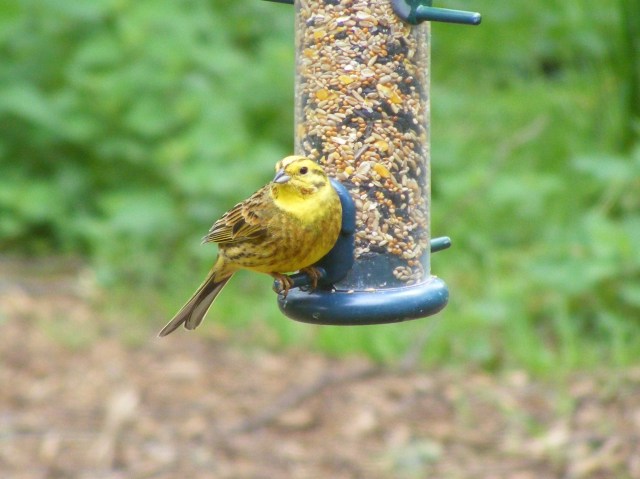
To make up for the lack of wildlife on the nonetheless awesome safari we do see a hare as we leave the site. We head to Osprey Haven at Loch of the Lowes via a slight detour round the golf club courtesy of our sat-nav. We are in luck here as three osprey chicks have hatched this week, the youngest is just four days old. We watch the nest from the hides and via the web-cam, seeing both parents on the nest feeding the chicks. We also see another osprey circling, which caused the staff some concern as it could be a threat to these chicks. I do love the ospreys but watching the birds on the loch and at the feeders is just as good, although again the red squirrels elude us. We get a great view of a pair of great-crested grebes and there are yellowhammers and randomly, a mandarin duck on the feeders. The latter has been visiting for several years and is thought to be an escapee from a private collection.
 Dave from Highland Safaris has recommended a visit to the Crannog Centre, which does not feature in the guidebooks or on any leaflets we’ve seen. We don’t have a great deal of time and we wonder if it is worth paying the entrance money. It so was worth it – an amazing reconstruction of an iron age structure complete with a variety of historical interpreters spinning, dyeing, cooking, boat making and creating an enormous set of bellows. With our own ‘neo-building’ experience, this is particularly interesting to us. The whole thing was fascinating, highly recommended.
I will pass on the snippets that we gleaned during our visit. A Crannog is an artificially created island and although there were earlier examples, nine were constructed on the loch between 600 and 400 BC, including the one on which this reconstruction is based. ‘Cran’ means branch and ‘og’ means young. Strictly ‘cran’ is ‘a branch shaped like a pregnant woman’. This led to the, now discredited, theory that these structures were birthing chambers. The word is medieval, not iron age like the islands and may refer to the shape of branches used. Not actually sure I quite buy this explanation. The original would have had a roof of bracken and heather, rather than reed but the charity cannot afford to replace the roof every two years, which would be necessary if bracken had been used and reed is not out of place for iron age structures. Each crannog would house fifteen to twenty people. The last inhabited crannog, lived in by nuns, was abandoned in 1740.
The experimental archaeologists tried several methods of erecting the main piles for the crannog. They discovered that trying to float them out in log boats is a fail, as you can’t stand up in a log boat without it rolling – result – a number of wet archaeologists! They ended up using a jetty instead. The walls are made from two layers of hurdles with bracken in between. Daub is impractical because of the weight. The structure would have been built in a single season and would last about eighty years, although they would begin to decay after about fifty years, with the piles rotting and the floors needing repair. Despite the lack of pollution in this area, piles now need replacing four times more often that they did in the iron age, due to the effects of the poorer water quality of the twenty first century.
There is a central stone fireplace but no hole in the roof. Instead, the smoke lines the underside of the roof, helping with the waterproofing. The excavations suggest that the crannog dwellers had a largely vegetarian diet, although animals were kept for dairying and wool. The animals would have been wintered inside part of the crannog. Meadowsweet was used to separate the curds and whey. Surprisingly there is no evidence here, or at crannogs elsewhere, that fish were eaten. This seems very odd. The theory is that those who lived on crannogs were of higher status and that they may have had a spiritual significance, perhaps acting as intermediaries between the land dwellers and the loch deities. Maybe taking fish from the loch was deemed inappropriate on religious grounds. What seems certain is that the crannogs had no defensive function and weapons have not been found, suggesting that this was a time of peace.
Loch Tay, in the centre of Scotland, was in an important trading position and perhaps 10,000 people lived round the loch, on land and sea, in the iron age. It is thought that the crannogs may have been built to save land that could be used for farming but this seems unlikely to me. Apparently the archaeologists found a collection of Mesolithic arrow heads that it seems a crannog dweller had collected and displayed. The crannog also contains an anachronistic eel trap, left by a basket weaver in residence. Health and safety means that the crannog is fully equipped with smoke alarms. I am not sure how this works when they light the fire.
All in all, a special day, with three highly recommended activities and it was topped off by being able to watch The Generation Frame, a Scottish genealogy programme, with people I know featured amongst the experts.


 Icebergs prevent us from getting right up Tracy Arm but we still have beautiful views to admire. It is too chilly to sit outside for long so we spend the morning in the Windjammer again, as breakfast blends in to coffee and then into lunch. Great to relax and chat as the scenery and icebergs flash by. I later realise that I spectacularly failed to get any close up iceberg photos. I seem to keep missing out on this trip.
 Our railway carriage, one of 83 in the fleet, is named Lake Klukshu. Skagway means ‘land of the north wind’ but we are fortunate that the weather is glorious, so we have great views of the White Pass and Yukon route. Following the discovery of what was actually very little gold, Captain William Moore, founder of Skagway, together with Skookum Jim, one of the two first nations people who found the initial gold, sought to establish a route to the Klondike that was easier than the existing Chilkoot Pass. Their route, past Lake Bennett, was named White Pass. A sensationalist newspaper headline about the discovery of gold, led tens of thousands of prospectors to take steamers up the inside passage and begin a hazardous 600 mile trek across country to the Klondike. No prospector was allowed to begin the journey without a ton of supplies. The slightly easier White Pass was favoured over the shorter Chilkoot Pass as it was, in theory, possible to take pack animals. Over 3000 horses or donkeys perished on the Pass before the railway on which we are travelling was constructed. They began building this narrow gauge railway in 1898 and reached the summit, 110 miles away in 1899. The route involves steep gradients and tight turns and construction was hampered by temperatures as low as minus 60. By the time the track heading north joined the track coming up from the south, in 1900, over 35,000 men had been employed in building the railroad at some point. The tracks ceased to carry ore after the price slumped in 1982 and the railroad became a tourist destination.
 Finally, we are able to dock and the sun is shining on the righteous and on us too. Juneau was a gold rush town, founded in 1880 and is now the state capital. We are invited to join a mad genealogists’ excursion to the Mendenhall Glacier in a hired mini-bus. The first challenge is to cram all twelve of us inside. This involves trying to avoid being garrotted by the seat belt that is strung across the doorway. It is a short drive to the glacier near Nugget Falls. Despite the name, virtually no gold was taken from here and in the early part of the twentieth century, money was made from hydro-electric power, before the area turned to tourism. We learn a little of the local Tlingit people. It is very peaceful here, despite it being a tourist honey pot. Sadly, climate change is taking its toll and the glacier is retreating at an alarming rate. We see some bald-headed eagles on our journey but not in a spot suitable for photographing.
