Dallying in Derbyshire 1

Preparing to leave our caravan site in the Lakes, the robin called to bid us farewell, bringing some of his friends, including a nuthatch. We had an uneventful drive south-eastward to Buxton. The landscape is notably different on the Peak District, with hills, open fields and mellow stone.

The Derbyshire site was adjacent to a country park so, once settled, we walked up to Solomon’s Temple, so named for local landowner Solomon Mycock and built in 1894 to replace a former building that was thought to have been commissioned by the Duke of Devonshire, to provide employment for unemployed lime workers in the 1820s. Archaeological finds suggest that this was the site of a Bronze Age burial mound, as artefacts dating from c. 3500 BCE have been found.

We had an early evening meal and left for Cromford where we had booked to see an open-air play. In fact we’d altered our holiday to arrive earlier in Buxton so we could do this. On arrival everything seemed shut and we could see no sign of an imminent performance. Having wandered around for half an hour and asked several people, I manage to find some mobile signal, rare since leaving home and checked the website to discover that the performance had been cancelled. As the play was about the gunpowder plot, I could understand that, in the aftermath of the Queen’s death, it might not be the most tactful time for a performance about trying to blow up a monarch but apparently the decision to cancel was only taken six days later. I was decidedly annoyed that no one seemed to think that it was a good idea to email those who had booked, to save them a round trip of forty miles, or indeed to put a notice of the cancellation on the firmly locked doors but hey ho. After five emails our not inconsequential entrance money was refunded.

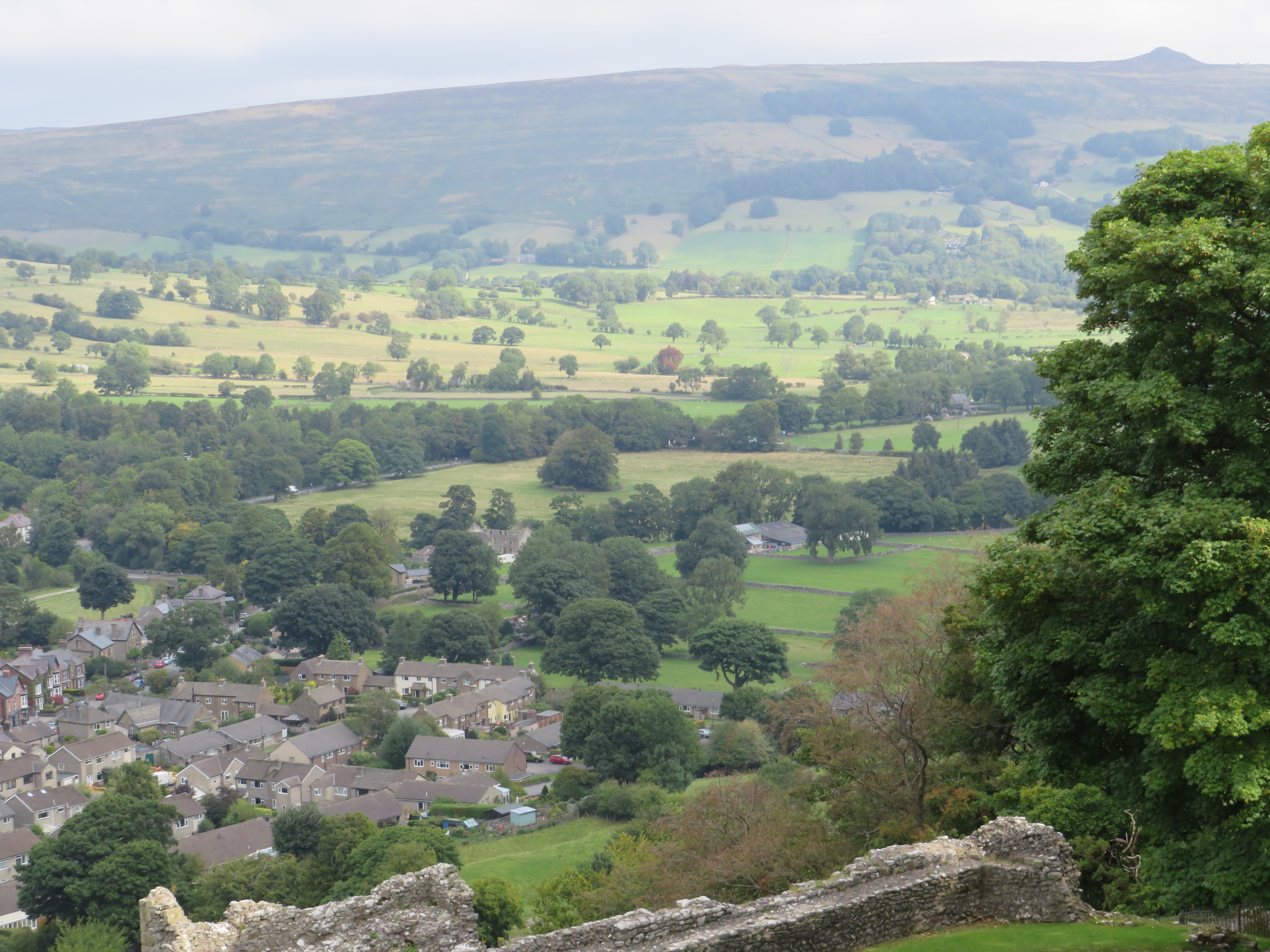
The next day we drove to Hope Valley and along Winnats Pass, with its impressive views across to Mam Tor, the site of a Hill Fort. The Hope Valley is the boundary between the millstone grit of the  ‘Dark Peak’ and the differing geology of the ‘White Peak’, an area of carboniferous limestone, with its elaborate cave system. Our destination was Castleton and Peveril Castle, one of many castles established after the conquest in the Forest of the Peak to establish Norman control. Originally called the Castle of the High Peak, the castle was later named for William Peveril, an early keeper of the royal forest. The castle’s purpose was more administrative than defensive, being a base for the Keepers of the Forest of the Peak from the eleventh to sixteenth centuries. Their role was to ensure that the punitive Forest Laws were adhered to; fines were paid and rents were collected. The value of the area to the crown lay in its use as a royal hunting ground and also the local lead and silver mines. Castleton grew up in the late twelfth century, its houses and mills providing an income for the castle’s estate. It was a stop on the packhorse route.

Although the castle was owned by the monarch or a member of the royal family, they rarely visited. Henry III, who was almost certainly responsible for constructing the New Hall at Peveril, only stayed once. Even after the building fell into disrepair, the castle continued to be used as a courthouse, prison and the local pound until the sixteenth century, after which much of the castle was demolished and the dressed building stone was plundered.

We looked at various gift shops selling the local Blue John or Fluorspar and read about John Tym’s Blue John workshop. We had excellent cakes and drinks in Dolly’s tea room, really good value too and highly recommended. Allegedly this premises, in a former incarnation, was billed the worst café in the country; definitely not the case now. A Buxton shopping trip yielded not only food but the adaptor required to download my photographs.

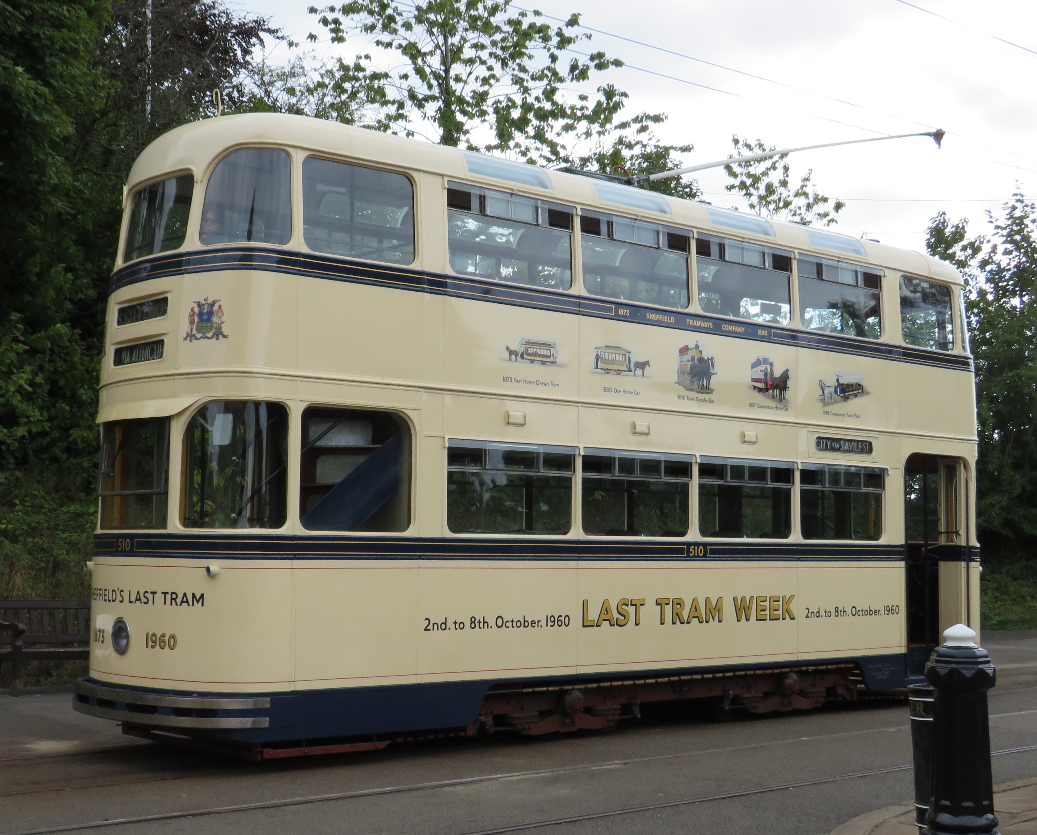
On Martha’s recommendation, we headed off to Crich Tramway Village without too much trouble despite a road closure. This haven for preserved trams was opened in 1959 after the former limestone quarry closed. This attraction is well presented and a credit to the largely volunteer workforce. The enthusiastic Ken showed us round. A random collection of items of architectural heritage have found their way on site but blend together. These include what remained of the Derby Assembly Rooms, which was built in 1765 and caught fire in 1963. Its brick by brick demolition and re-erection took three years. There are two 1897 gas lamps, from Ashton-under-Lyne, originally cast to commemorate Queen Victoria’s diamond jubilee. The gates came from Marylebone station, there’s a tramway shelter from Matlock and a Hendon police phone box. The Red Lion pub from Stoke on Trent was particularly notable, as was one of the last twenty ‘Penfold’ hexagonal Victorian post boxes in the country. One of the more bizarre artefacts was the ventilation pipe from an underground Birmingham toilet.

We road on two trams, one a 1928 from Porto, Portugal. There were many more trams to view and a huge exhibition area. We took our second tram on a one way journey so we could walk back through the woods and view the wooden sculpture trail. We could see the Sherwood Foresters’ War Memorial, which marks the highest point in Derbyshire. There is a view of eight counties from here but access is restricted at the moment so we couldn’t walk up to it. The road closure was a little more impactful on our return journey but we made it back without too much of a detour.

Welsh Adventures Part 3

The final instalment chronicling our adventures in Wales and beyond.

Day 7 Blaenavon Ironworks

We set off for our pre-booked entry at Blaenavon Ironworks. This time the sat-nav, not only gets us to the right place but takes us past some stunning scenery on the way. Blaenavon Ironworks is a fascinating site. We get in free because Cadw, who run the site, have a reciprocal arrangement with English Heritage. The ironworks were established here in the 1780s and the finished products were shipped out by canal. It was at Blaenavon that Sidney Gilchrist Thomas discovered a way to remove phosphorus from iron ore, which was significant for the steel industry. An impressive digital display gave some idea of the noise and heat that was part of the working environment. It was somehow more impactful because part of the commentary was in Welsh. I am drawn to ruined industrial landscapes and this is on par with the Cornish tin mining sites. Here the jackdaws and the feral pigeons have made their home.

A series of workers’ cottages on the site have been furnished to represent different eras from the 1780s to the 1960s, the life of the ironworks. Covid restrictions mean that we can only look in these cottages, rather than enter them but they are still a highlight of the site. Instinctively, I wanted to look them up in the census returns and mentally put real people in them. This is just the sort of site that anyone with ironworking ancestors should visit. An interesting fact that I gleaned was that, in 1851, there were more industrial workers in Wales than agricultural, allowing Wales to claim to be the first industrialised nation in the world.

We went for a short uninspiring walk from close to the car park then headed off home, planning to stop to take photographs of the view on the way. We hadn’t done so on our outward journey as we were keen not to miss our entry timeslot. Strangely, the sat-nav decided to return us to Brecon via a completely different route. Although a circular route has the advantage of exposing us to more of the country, we are disappointed to miss the views. Just as we are lamenting this, the landscape opens up and the vista is amazing. Squelchy bog prevents me getting a great camera angle and views always seem less impressive in photographs, so I will have to rely on memories. The mid-Welsh landscape seems to be darker green than many areas and fields tend to be small and hedged, despite the availability of stone for walls.

On the way home we are reminded that the Brecon Beacons have their fair share of ******* drivers. We reach a bridge that it not only described as weak but is barely wider than the car. This in itself is not a problem but like many Welsh roads, it is not straight and at the point at which you join the bridge you cannot see the end of it. An illuminated sign warns us that there is a vehicle on the bridge. A vehicle emerges the sign goes out and a green light comes on. We launch into the unknown, only to find, as we turn the corner, that someone is coming in the other direction, presumably having ignored the sign at his end. My gallant chauffeur had to reverse 100 yards round corners, with unforgiving walls no more than six inches from the wing mirrors on either side.

Day 8 Thursday Brecon Canal

Today it is sunny, so we decide to walk from the caravan site, down the canal towpath to Brecon. This involves taking our lives in our hands to cross two dual carriageways first but we survive. This is a pleasant walk and we are rewarded by a grey heron allowing us to get to within five yards before flying off. There are more signs of industrial heritage here, with the remains of the limekilns that were in operation in the early nineteenth century. The canal linked Brecon with the industrialised areas in south Wales.

After a short rest we decide to explore more byways of Wales by car. We drive out to Craig-y-nos Country Park but by the time we arrive, dark clouds are looming and as we have already had our walking ration for the day, we return to the van.

Day 9 Friday To Cheltenham (yes, I know this isn’t in Wales)

It is time to move nearer to home and take up residence at the caravan site on Cheltenham Racecourse. We have stayed on racecourses before and although we have views across what is probably the Malvern Hills, I have to say that it isn’t the most picturesque site we’ve been to. Cheltenham too is unexpected, much larger than I was anticipating. In my head I was thinking smallish, Georgian grandeur, maybe a bit like Buxton but it seems not, or not in the part we travelled through.

I hadn’t planned an activity for the afternoon so time to Google for an outside space. I lied when I said that the wifi on the previous site was the slowest in the world, that honour belongs to the Cheltenham Racecourse wifi, which is not the Caravan Club system, for which I have an annual subscription but free Jockey Club wifi. I guess there isn’t much call for surfing the internet when hurtling over jumps on the back of a horse. An additional issue is that we have the ‘delights’ of a ‘Fun Weekend’ event on the racecourse this weekend – deep joy. This appears to involve a fun fair. Peaceful it may not be.

We opt for Beckford Nature Reserve. This comes very close to being another addition to our ‘nature reserves we didn’t find’ list but no, here it is, unsigned until you get to a small gateway hidden in a hedge. A path winds round an algae covered lake. There’s not much sign of wildlife apart from some baby coots, which I am surprised to see have orangy-coloured heads. Despite two perambulations of the lake, I am still 1500 steps short of my target. Time for some jogging up and down on the spot outside the van. This is followed by the Wimbledon men’s singles semi-finals.

Day 10 Forest of Dean

It wouldn’t be a holiday without some family history, so today it is off to the Forest of Dean, the haunt of some of my children’s ancestors. This lot even rate some gravestones, though many were in poor condition. Trailing from churchyard to churchyard is often circumscribed by bladder capacity, because small villages rarely rate toilets but hurrah, today two of the churches on our itinerary had toilets, so we could happily spend hours peering at semi-legible gravestones.

One of our stops is at St. Briavels. St. Briavels Castle, now run as a Youth Hostel, is closed to the public. It was built as a royal hunting lodge in the twelfth century. It became an important centre for the making of cross bows, using iron from the Forest of Dean.

Having got suitably soggy feet from traipsing through grassy graveyards, we take a short walk along a forest path to keep the step count up. Then it is back to the van, where the wifi oscillates from intermittent to non-existent. I hurriedly identify today’s photographs. In the past, I have been known to end up with numerous church photos and not be quite sure which is which.

Day 11 Slimbridge

We have saved the best until last. Today is our pre-booked visit to the Wildfowl and Wetlands Trust centre at Slimbridge, established by Sir Peter Scott seventy five years ago. Last time I visited it was in the spring so there are different things to see today and the opportunity to feed birds is confined to a small area. My favourite part is the new estuary aviary with avocets, oystercatchers, black-tailed godwits, ringed plovers and spoonbills, amongst others. I manage to get a few half-decent photos, despite every bird assiduously going into a preening frenzy at my approach, so that their head are hidden from view.