I wake up early as usual. This is just as well as we need to leave the van at 7.00am and something weird has happened to my alarm clock, which thinks it is still 1.00am, so it would have been no good relying on that. What more can go wrong? We drive across Skye to Uig. Chris is convinced that this is pronounce ‘You-eee’ and he has been here before so who am I to gainsay him. I would like to place on record that we were not first in the ferry queue, nor indeed, second or third. The ‘Hebrides’ ferry arrives with a distinctly worrying tilt to starboard. We can only hope that this does not have a detrimental effect on our voyage.
We are bound for North Uist and by the judicious use of bridges, will be able to visit five islands for the price of one. Okay, so it was quite a substantial price but there are only two return ferries and one of those leaves five minutes after we arrive. The other is later than we might have chosen but it does mean that we will have plenty of time to explore. On the journey across, we see, ranged across the skyline, the myriad of rocks that make up the tiny islands of the Outer Hebrides. From a distance, they resemble the humps of the fabled Loch Ness monster.
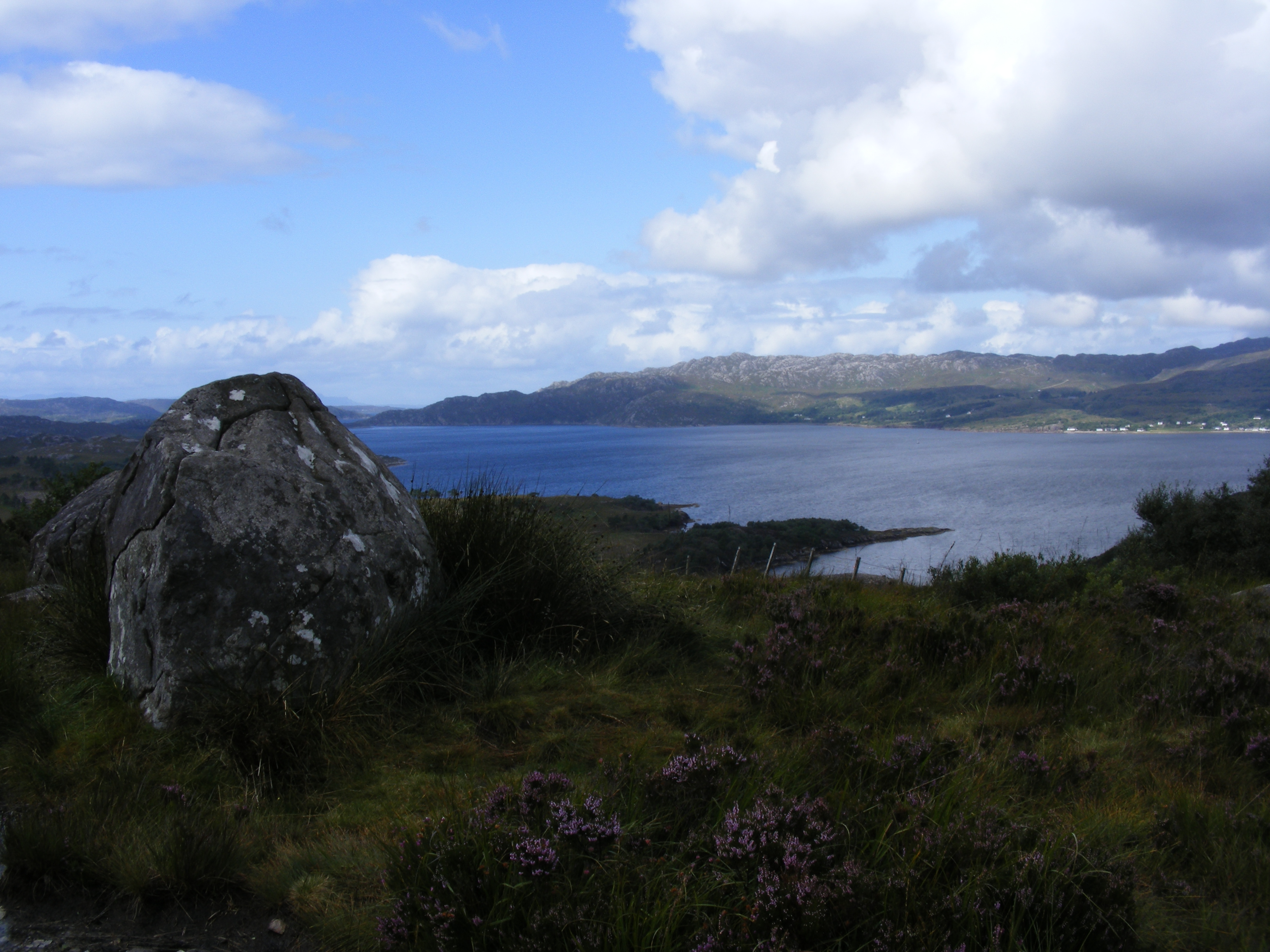
I have brought my laptop with the intention of finishing the Buckland Brewer History Group newsletter whilst on board and make good progress. As the ferry draws in to Lochmaddy we see notices that instruct us to ‘wait for instruction to move before starting engine’. How difficult can this be? Very difficult it turns out, as most of our neighbours are turning their ignitions before the ferry’s ramp is lowered. North Uist, where we land, is distinctive, much flatter than Skye, with many inlets and stretches of water. At last heather is in abundance. I opted to visit this chain of five Outer Hebridian islands, rather than Harris and Lewis, primarily because I liked the sound of Benbecula. First stop is the island of Berneray, so we head north. Like much of Skye, this is single track road with passing places, involving much slowing down and changing of gear. The road is blocked by a van pulling a trailer containing a digger. We wonder why they are hunting around in the ditch instead of moving out of the way. Ah, they are searching for one of their trailer wheels, that explains a lot.
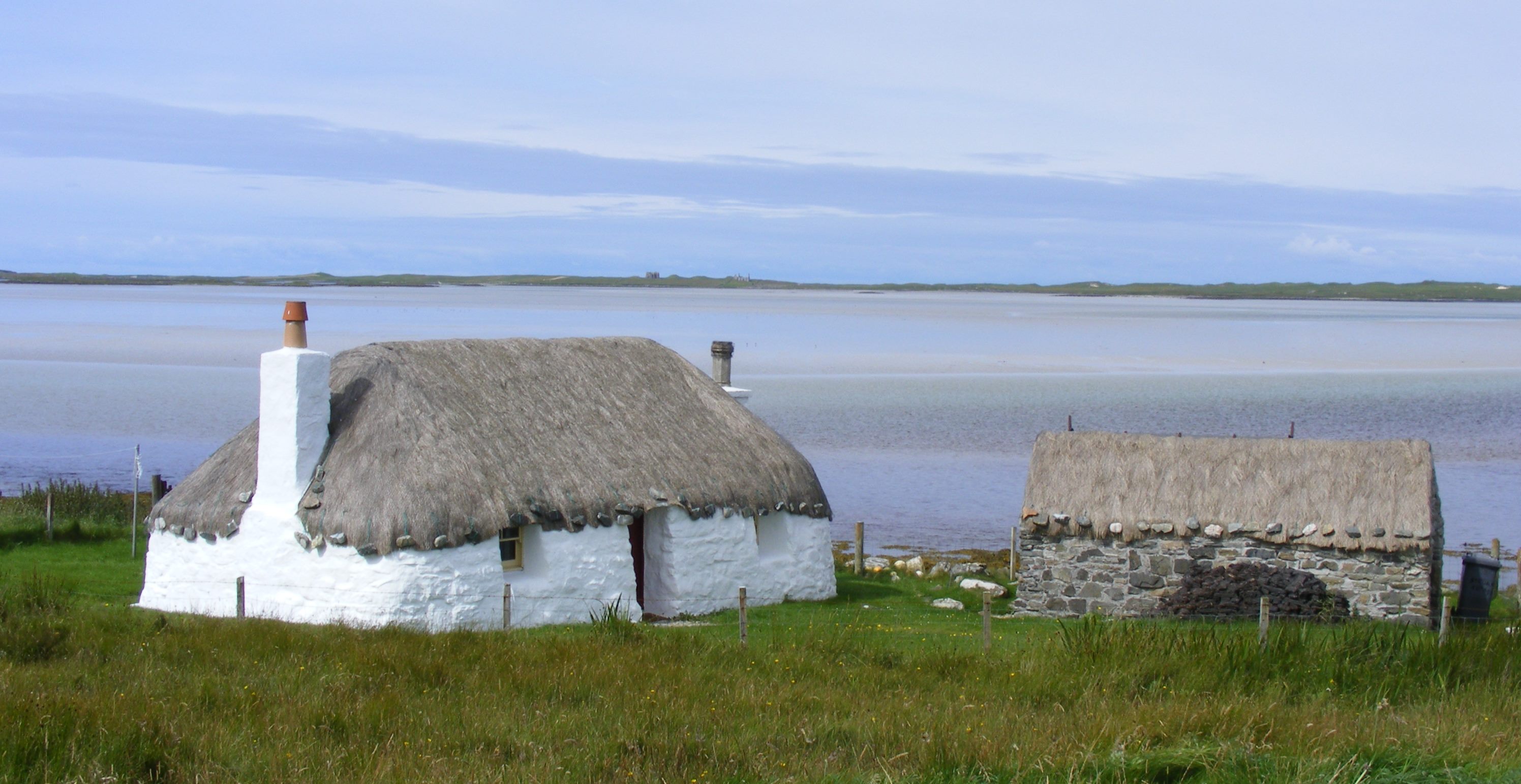
The mobile bank arrives as we draw up at the only shop on Berneray. Chris attempts to get them to part with money but they can only cope with Royal Bank of Scotland customers. We call in at the Berneray Heritage Museum in the old nurse’s house, given to them by the council for a peppercorn rent when the district nurse was discontinued. Worryingly, there were not only problems with the paperwork relating to the original purchase of the building but also with the lease, so they may be on borrowed time. We learn that kelp gathering and horse breeding were the staple industries here. Of a 1911 population of between 500 and 600, 86% were Gaelic speakers, although schooling was in English. Each child took a piece of peat to school every day for the fire. In the 2011 census one Berneray resident from the 1911 census was still on the island. The museum even has a photo of a yacht that Chris’ Devonian grandfather crewed, along with men from the Western Isles. We learn of Angus MacAskill, born on Berneray in 1825, who is accepted as being the world’s tallest man ever at seven foot nine inches. We ask about some of the traditional ‘black houses’, which here have a roof that slopes down inside the line of the front and back walls, leaving a shelf like projection at the top of the wall. We are told that this is to deflect the rain so that it doesn’t drip on those leaving the dwelling. This doesn’t seem very logical to us as surely this makes the walls more vulnerable. The island location means that there is rarely snow here so roofs do not have to cope with that.
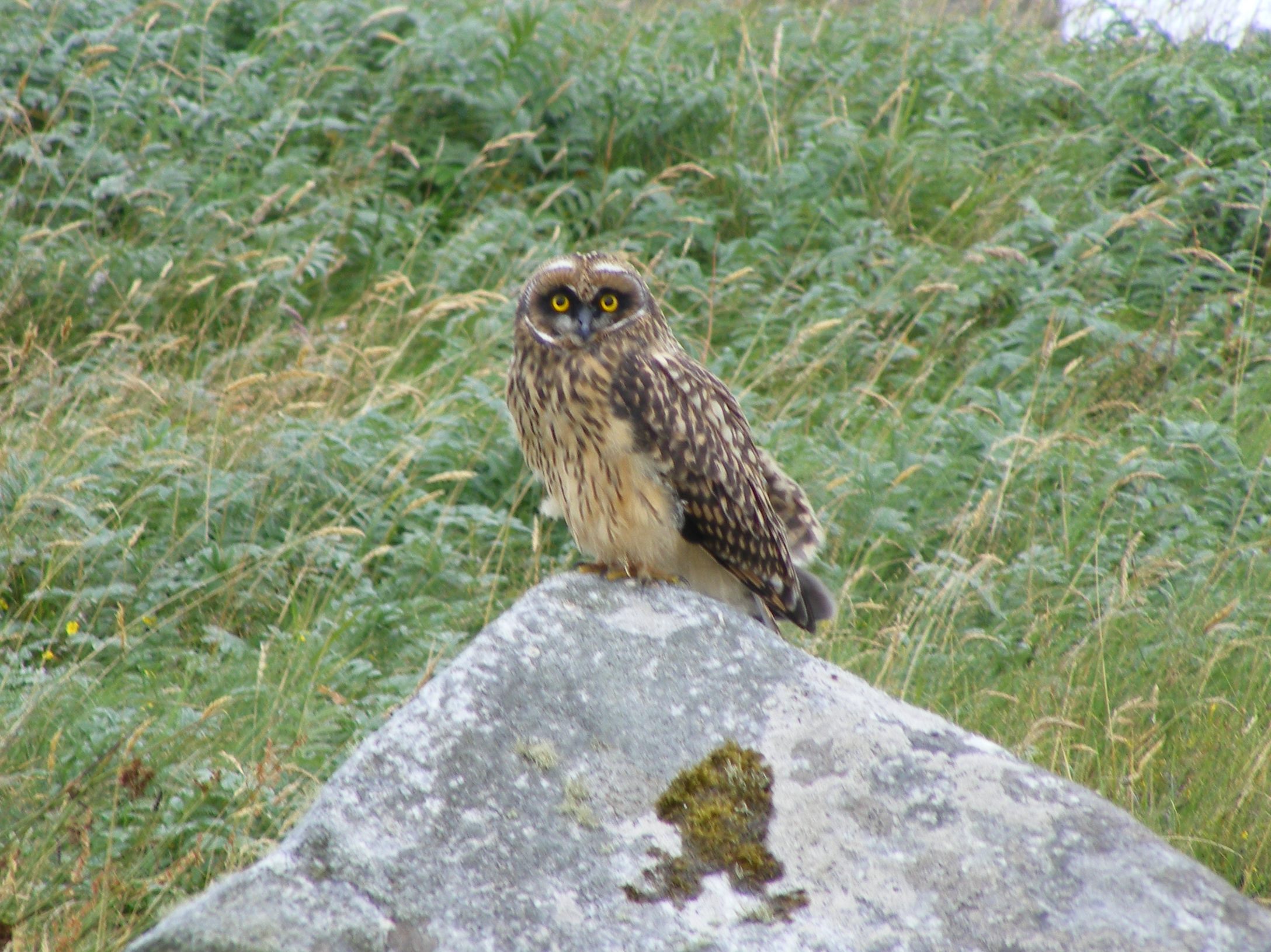
 Back on North Uist we somehow miss the RSPB reserve but nonetheless see lapwing, hear curlew and manage to take a photo out of the car window of a short-eared owl sat on a rock. Our progress is hampered by playing dodge the sheep on the narrow road. We stop at the ruined Trinity Temple, allegedly Scotland’s oldest university. It was a medieval monastery and college founded by Beathag, daughter of Somerland. After an extension in the sixteenth century, it was dissolved during the Reformation, although there were later repairs.
Benbecula may have a cool name but it contains the least of note of today’s islands. As we traverse it, along the slightly longer coastal route, the car begins to make a strange noise. The driver seems unperturbed (or is a very good actor) and we continue to weave our way in and out of the passing places in order to venture on to South Uist. Flora MacDonald was born here, near Kildonan. It was she who helped Bonnie Prince Charlie to escape after his defeat at Culloden in 1746. Peat cutting and kelp gathering are still carried out here. South Uist is hillier than the three more northerly islands in the chain. The car is still not well and there are mutterings about a lack of clutch fluid. We stop at Kildonan Museum, hoping that letting the car cool down will help it recover from the excesses of gear changing over the last couple of days. Kildonan Museum is another example of a Scottish community valuing its heritage in a way that is not seen in England, with archives and research opportunities available on site. South Uist is the heartland of Gaelic culture, home of oral tradition and Fair Isle knitting. There are several telling quotations round the museum’s walls. ‘There is always a danger that history comes to mean the past, as opposed to an interpretation of it.’ and ‘However we interpret it, there is nothing surer than that history has as much to do with the present as the past.’
 On leaving the museum, we find that we no longer have to worry about the clutch being overheated; there is no functioning clutch. We have to abandon plans to reach Eriskay, the southernmost island of the chain, noted for its wild ponies and the wreck of S.S. Politician in 1941. The vessel was laden with 260,000 bottles of whisky and its story became the basis for the book and later film, ‘Whisky Galore’. We limp back towards Lochmaddy, attempting to do so without stopping or changing gear, next to impossible on a single track road. In the middle of absolutely nowhere we find a lorry servicing garage. The mechanic confirms the demise of our clutch. The good news is that he can fix it on Tuesday. It is Friday. If that is the good news I don’t want the bad. We are four islands away from our caravan and several miles from anywhere where we could potentially sleep or obtain food. I have only had a lemon muffin since 6.00am and even Chris’ full English breakfast on the ferry is a distant memory. Now comes the very long wait while the recovery service try to work out if they can indeed recover us. Chris is patiently spelling out our current location, once we confirm where that is, where we have to get to, via where and most importantly by when. We really need to get that ferry back to Uig.
I’ll admit it, I am hopeless at doing nothing. I could read my Kindle but the battery is low. I could use the laptop – ditto. What about good old pen and paper. I can manage the former but the car is lacking in anything to write on. Finally I locate a single A4 printed receipt that I took to exchange for our ferry tickets. If I write very very small I can occupy myself for a while using that. I need something to stem the rising tide of panic, made worse by the fact that we have very little cash, thanks to not being RBS customers and that Chris’ phone battery, like every other battery in our possession, is getting very low. I know, I know, this is a time when I need my ‘emergency phone’; inevitably it is back at the caravan.
After what seems forever, recovery truck one arrives. The car is loaded and the driver ferrets around in the back for something resembling a seat to put in the middle of the cab for me. This ‘seat’ doesn’t rate a seat belt but this seems not to matter. I am sandwiched between a broad Devon accent and a broad Gaelic accent, acting as interpreter but truth be told, I could only follow half of what our rescuer was saying. I did catch the bit when he said he though his clutch was going but I ignored that. In the process of getting the car on the truck it was apparent that no way was our car going anywhere, like on a ferry, unaided. Understandably, our driver would rather not have to tow us on and become marooned on Skye overnight. Not to worry, this is the Outer Hebrides, everyone knows everyone. In the queue there is a random van, with someone known to our driver at the wheel. He is approached to tow us on and off the ferry and our driver even donates a tow rope as a souvenir. I look pathetically at the dispatchers, not difficult as I am both sleep and food deprived and they agree to load us as a towed vehicle, by no means a foregone conclusion. Despite our lack of automotive capacity we are on the ferry.
The ferry is half an hour late arriving and all we want to do is get home but finally we are aboard. After consuming the welcome curry from the café, there was the issue of getting off the ferry. Our helper accelerates away at a great rate and the tow rope snaps. We tie it together but it was short to begin with and now Chris is very close to the almost new van in front. He manages to avoid running in to it and we are handed over to recovery truck two. We are on Skye, this driver drives at Skye speeds. I do have a seat belt this time but as he hurtles round the many twists and turns our knuckles are whitening rapidly. We arrive at the garage, deposit the car and collect a courtesy car that has been left out for us. We are still an hour and a half from ou destination. Arriving back just before 1.00am, I don’t think we have ever been so pleased to see the van. Now we have to work out how to cope when we are fifteen miles from a shop or a phone signal and fifty miles from our car. Thank goodness for the internet connection. Working out what needs cancelling or rearranging in order to get our trip back on track can wait until morning.
 It is interesting to fully appreciate that Cumberland’s government red-coat army of 10,000 men would need 10,000lb meat and 10,000lb bread each day to sustain them. The lack of supplies for the Jacobite forces was a significant feature at Culloden, along with the boggy terrain which led to the failure of their previously successful charging technique. The battle lasted less than an hour and nearly half the 1500 Jacobite casualties fell in the few minutes of this failed charge. The government troops lost only 50 men, although some of the 250 wounded died later. The Irish and French, who were fighting for the Jacobites, shielded Bonnie Prince Charlie’s retreating army, who headed for Inverness after the battle. These Irish and French were subsequently treated as prisoners of war not rebels. The Jacobites did regroup at Ruthven and were prepared to fight on but Bonnie Prince Charlie sent orders to disperse and the cause was lost, leaving Charlie to escape ‘over the sea to Skye’ with the aid of Flora MacDonald.
 Our site at Dunnet Bay is exposed but right by the sea and we have a pitch that has what might be classed as ‘sea glimpses’. After setting up the van we depart for John O’Groats, well you have to don’t you? It isn’t quite as commercialised as Land’s End or Gretna Green and it seemed important to visit what claims to be the most north-easterly settlement in Britain. There are some weird multi-coloured wooden buildings, which are apparently extensions to a hotel. If they were trying to look like Balamorey they’ve failed. A little like Land’s End it isn’t actually the extremity that people would have you believe. Dunnet Head is the most northerly point and we plan to visit there before we leave. We are primarily in John O’Groats to pick up our tickets for tomorrow’s trip to Orkney and to see where we need to be first thing in the morning. That accomplished, we move on to Duncansby Head. We arrive in a fierce hail storm and decide to sit it out, hoping for a gap in the precipitation so we can visit the fulmar colonies that nest on the cliffs here. Yes, Scotland’s weather does it again and within ten minutes it is dry and we decide to risk it. The ground however is anything but dry and is best described as spongy. Chris has his walking boots; mine are in the van so I paddle along in trainers as far as Duncansby Stacks.
 As we have come quite a distance to spend not very long looking at the barracks we decide to stop off at Loch an Eilean on the Rothiemurchus Estate on the way back. The original plan was to walk four miles or so round the loch. By this time it is not only 5.00pm but very cold and drizzling so, despite having made a financial investment for car parking, we just take a very short walk along the loch side to see the castle in the middle of loch. We try and fail to find the monument to Major General Brook Rice who drowned in the loch whilst skating. This is allegedly the number one picnic place in the UK. I debate whether this is a self-styled title. I am sure it would be very lovely if the temperature were fifteen degrees higher. Having satisfied ourselves that we have actually done something today, we head for home. The weather forecast for our booked trip on the funicular railway tomorrow is not encouraging, ah well, this is Scotland and rain it must.
 It is a lovely sunny day, contrary to the predictions of weather forecasters, although there is still snow on the nearby peaks. We take a walk a mile or so into Killin and follow some of the heritage trail. Here we are in what is described as ‘The Heart of Breadalbane’, or the high country of ‘Alba’, which was an ancient Scottish kingdom. Killin is a natural place for a settlement as it is at the confluence of the Dochart and the Lochay rivers. Our walk takes us as far as Dochart Falls, which are beautiful.
 We are out of practice with walking and have done no more than gentle strolls since our accident last year, so we are unsure how we will hold up. We decide to walk for two hours and then turn round. As two hours approach, we enquire of one of the many people heading in a clockwise direction, how far it is all the way round the lake. We are told it is eight miles. It is a little rough in places but flat so we change our plan, as it seems it would only be a little further to complete a circumnavigation and it it always preferable to have a circular route. There are plenty of wildflowers to observe and we see many tadpoles in a large puddle. None of the ramblers’ group coming in the opposite direction seem to have been observant enough to spot these, so we point them out.
 Next day and it is off to a supermarket near us to stock up. Pizza seems like a good idea, just a shame that the one we chose was larger than the fridge. I have a way of solving that but not one that is commensurate with watching what I eat. We run the gauntlet that is the stop start, roadwork-ridden M5 and M6. Then a comfort stop at a services near Preston. There are ten long spaces especially allocated for caravans. They contain three caravans, one of which is us and seven things that are patently not, by any stretch of the imagination, caravans. It isn’t as though there aren’t very large signs explaining the situation and ample empty car spaces very close by. I am tempted to remark, ‘what a strange caravan’ in a loud voice but I just manage to restrain myself. The next caravan owner that arrives and finds nowhere to park will be serious p****d off. We know this is the frozen north and folk are hardy up here but I am not sure that, despite the sun, this is really sitting outside in tee-shirt weather however many people are braving the still chilly wind as if this is summer.
 I have to say the ‘interesting’ access was worth it. This is a truly beautiful, wooded setting, only yards from the footpath round Derwent Water. We have just got set up and the kettle on as Hazel and Martin arrive. Sadly we can’t offer them a drink as we only have two cups. We chat then head off to Mary Mount to eat – not the most inspiring name but great hunter’s chicken and stupendous views of the lake. Weirdly though, when we tried to book, we were told it was full but we could sit in the bar. In the event we sat outside but the restaurant seemed far from full. We finish the evening with a quick walk round part of the lakeside, heading in a clockwise direction.