For those of you saying ‘Are we nearly there yet?’, not too long to go now, we should make it in six more episodes after this one.
This was a day of continual heavy rain, interspersed with intervals of torrential downpours. In poor visibility, we headed for Killarney and although it wasn’t our original plan, decided to begin the day indoors, in the hope that the weather might improve. Spoiler alert – it didn’t. Killarney is noted for its horse and cart trips. These are known as jaunting cars and as we drove up to our destination, Muckross House, we accidentally ended up at the jaunting car entrance instead of that for regular cars. We manage to end up where we needed to be and were pleased to see that this wasn’t quite so overrun with tourists as some other places we’ve been.
The Herbert family settled at Muckross in the early 1700s. In 1837, Henry Arthur Herbert married May Balfour, who he met whilst on his Grand Tour and they commissioned Muckross House, which was completed in 1843. Henry became an MP and they entertained Queen Victoria at Muckross in 1861. The estate was heavily mortgaged and was let for hunting and fishing. There was certainly a preponderance of dead animals on display, including the ubiquitous 10,000 year old Irish Elk antlers. The estate was sold firstly to a member of the Guinness family and then to the Bourn family, before being given to the nation in 1932; it became Ireland’s first National Park.
I particularly wanted to see the traditional Irish farms, which were adjacent to Muckross House. Had we followed the route I tried to persuade the satnav to take us, we would have arrived here on time for them opening at 1pm, having circled Killarney National Park first. Clearly the satnav though only a lunatic would want to climb narrow mountainous paths in driving rain so we ended up in Muckross rather earlier than intended. Having exhausted the craft shops and resisted the temptation to buy stuff we didn’t need, the only remaining indoor option was the café, remarkable for its amazing selection of cakes. We made our refreshments last as long as possible then I swapped my not actually as waterproof as all that shoes for wellies and we took a quick and very damp tour round the grounds.
Next, an equally damp but worthwhile visit to Irish Traditional Farms, depicting a small, medium and large farmhouse from the area, as they would have been in the 1930s, although the actual buildings were older. There were people in the buildings to tell us their history and each farm was equipped with livestock. There was also a working blacksmith, who demonstrated his craft with incredible skill.
Having completed our tour, we debated whether to go straight back to the van or to go via the scenic route. Given the weather, there would be precious little scenery visible, so we decided to call it a day and head for home. Ironically, when I was first planning this trip in 2019, thinking it might be in 2020, when clearly it didn’t happen and when I was revising the plans for this year, I was reassured that the only family history that might be involved was the visit to Ballyedmond. It wasn’t until this point in the holiday that I remembered that some of my grandchildren were 1/16th Irish. To be fair, I don’t think I knew this in 2019. Arggh. What ancestral locations had I missed? A quick rush to the research notes. It turns out that all I know is ‘Ireland’. A bit more work and my strong suspicion is Tipperary. I will have to leave the ancestral photography to them if they ever visit.
As we didn’t have too far to travel and we didn’t want to arrive before check in time, there was time for a look round Adare first. We have already seen quite a bit of the main and almost only, street from the car, as the traffic doesn’t tend to flow very quickly through the town. Adare is a very pleasant looking settlement, much of which is a nineteenth century estate village, with attractive thatched cottages, set out by the Earl of Dunraven. We found a free car park on the outskirts of town; possibly rather more outskirtsy than ideal. First stop was the heritage centre where we could have booked a guided tour if we’d had time. There was a small exhibition which rather gave the impression that it was no longer a priority. Here we learned that Adare Castle was built in 1220 and was owned , briefly, by Geoffrey de Marisco in the 1220s. Cromwell ordered the dismantling of the castle in 1657 and most of the village was destroyed. We wondered if this was the same Marisco family who owned Lundy Island. We had a quick look in Adare’s Catholic Church but the incense was a bit overpowering for a long stay; it was once part of Ireland’s only Trinitarian Monastery, founded in 1230. The aim of the Trinitarian Order, which originated in France, was to rescue those who had been taken hostage in the Holy Land during the Crusades. There is also an Augustinian Friary in Adare, founded in 1315 by John FitzThomas FitzGerald. It was known as the Black Abbey, from the colour of their habits.
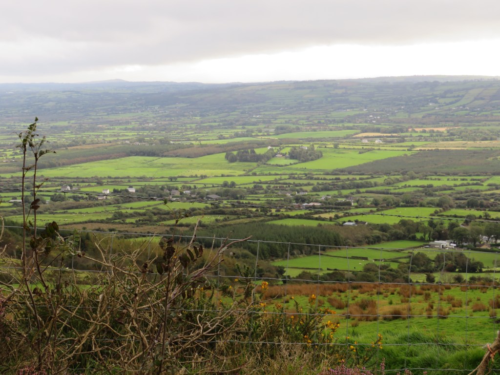
We drove on to our penultimate campsite at Glenbeigh. En route there were numerous charity collectors in the middle of the road at junctions, roundabouts and traffic lights. We have also seen this elsewhere This did seem to be effective, if inordinately dangerous. I can’t believe the charity’s risk assessment takes account of this. The route took us through the beautiful Kerry countryside and the site is nestled at the foot of the mountains, close to the coast. There is more heavy rain forecast for the next week, We can only hope that the forecast is about as accurate as it has been for the past few days.
Day 25
This was the day that our luck with the weather finally ran out. Undaunted, we set off in mist and rain to err ‘view’ the scenery of the Dingle Peninsula, well in theory anyway. A clear sunny day would have been glorious but it could have been worse and we did see some spectacular views through the drizzle and cloud. There’s a Ring of Kerry and a Ring of Beara but no Ring of Dingle, probably because the Brandon Mountain gets in the way. Instead, there is more of a figure-of-eight that takes you round the Dingle Peninsula.
We started heading westwards along the south coast of the peninsula, dropping south of the N86 between Anascaul and Dingle, to remain as close to the coast as possible. The route we took is highly recommended, especially if you aren’t blessed with a rainy day when the wind was strong enough to make it difficult to stand up straight. It also requires a driver who isn’t fazed by single-track, twisty roads and who can reverse up the same when something comes in the opposite direction.
We paused for a short while in Dingle to see if there were any interesting fishing boats; there weren’t. Then round the westernmost point and back to Dingle before heading northwards between Brandon Mountain and Stradbally Mountain. Inevitably, this took us up and what goes up must come down, so down as well. Here we were warned that we should turn round if our vehicle was more than six foot wide. We were pretty sure the car was indeed more than six feet wide but things seemed to be coming the other way, so we pushed on. There was a scarily sheer drop to my left and not very far to the left either. On the right towered the granite cliffs, as the narrow road twisted back and forth and we were rewarded with the sun shining on the north coast. Despite the limitations of the weather, the Dingle Peninsula has edged into first place on my best scenery list.
The satnav was deliberately set to shortest route, rather than quickest, which meant that we did not travel on the N70 from Tralee to Castlemaine but on the road that passes through the Slieve Mish Mountains. It is definitely worth going this way if you are confident driving in the conditions mentioned above.
Next was a supermarket shop in what was probably the most inadequate supermarket imaginable. It began by us circling said supermarket looking for its car park, only to discover that there wasn’t one. We secured an on street parking space and then found a distinct lack of things that we were hoping to buy. To top it all, there was only one check out and we arrived with our modest basket full (it would have been less modest if they’d had what we wanted) just as someone began unloading €200 of shopping.
Sorry for the break in transmission. We are now safely back home but you still have a way to go, partly because I don’t normally post holidays in real time but also I’ve been hampered by being in places where the wifi required me to huddle under a tree and for most of the time we were on that site it was raining.
It was time to head eastwards and for once, avoid the outskirts of Limerick. We drove through Tipperary. It has indeed been a long way for us, 2193 miles since we left home. We arrived at Rock of Cashel, another of the guide book’s top ten, coming in at number nine. This meant the inevitable thirty strong queue for the toilets. I decided I could wait. It was just as well, as this meant we arrived just at the right time. A flash of my English Heritage life membership card and we were whisked through like VIPs to join the guided tour that had just started. Rock of Cashel was the seat of the kings of Munster from the fourth century until 1101, when it was given to the church. Brian Boru, later High King of Ireland, was crowned here in the tenth century. On the site is St. Patrick’s Cathedral, a defensive tower house, the hall of the Vicar’s Choral and a round tower.
We went into the Cathedral first. St. Patrick’s Cathedral was built in the thirteenth century and replaced an earlier structure. The tower was added in the fourteenth century. It is a gothic, cruciform cathedral with an exceptionally short nave. Normally the nave is twice as long as the choir. Initially, the lack of space meant that they were built the same length but to make room for the tower house, the nave was shortened further to become just half the length of the choir. This was thought to make the cathedral unlucky. The height of the lancet windows was reduced by a third when stained glass was installed. This was a money-saving exercise, as the glass was so costly. Following the Reformation, the Cathedral was Protestant but it was taken over as a Catholic Cathedral in 1641. The Earl of Inchiquin regained it for the Protestants in 1647. He arrived with 2500 soldiers to find 800 people taking refuge in the cathedral, guarded by just 300 soldiers; they were all massacred and the interior of the cathedral was destroyed. The building was abandoned in 1748 and some of the roof removed to avoid paying tax. Massive storm damage in 1848 led to further deterioration. Fragments of a thirteenth century wall painting survived because it had been plastered over after the Reformation. It was rediscovered when a builder accidentally knocked off some plaster.
There were spectacular views from the rock across, we were told, ten counties and we had clear blue skies; luckily the forecasters got today wrong. In a field below was Hore Abbey, also known as St Mary’s of the Rock. It was founded in the 1270s as a Benedictine Abbey but the Archbishop David MacCarwell evicted the Benedictines in favour of the Cistercians. The legend is that this was because he’d had a nightmare in which he was murdered by Benedictines. He was unpopular for spending money that was earmarked for the building of a hospital on the abbey.
Our precipitate arrival meant we had the magic green wristband that allowed us entry into Cormac’s Chapel. There was extensive restoration in 2009, in order to try to remove the moisture from the chapel and visitors are now limited because they tend to breathe, which was having a detrimental effect. Cormac’s Romanesque Chapel was built between 1127-1134 by Comac MacCarthaigh, King of Munster. It contains the first known spiral staircase in Ireland. Entrance is now via the back door under a tympanum depicting an animal that is probably meant to be the bull of St. Luke, despite it looking like a hippopotamus. The front door was blocked off by rival kings. There is a twelfth century sarcophagus inside that has Scandinavian style decoration. It was moved to the chapel from outside to preserve it; this involved removing a wall. There are also some remnants of frescoes from the 1170s, when Henry II visited Ireland and convened the Synod of Cashel. They were done by an artist who also decorated Henry II’s chapel in Normandy and they use expensive pigments including lapis lazuli from Afghanistan.
We looked in the Hall of the Vicar’s Choral, built in the 1420s by Archbishop O’Hedian. This has been styled as it would have been at the time, which means there has been heavy restoration and use of replicas, which is a shame.
There was a bit of a debate about whether we should move on to Kilkenny, which was a further thirty eight miles east and eighty five miles from our campsite but it was, after all, number three in the guidebook charts. We decided to go for it. On arrival we had to look for a car park, which was fairly easily found and very cheap. It did seem to be at the ‘wrong’ end of the city in quite a run down area. There had been signs to the Castle from 40km away but once in the city, could we see any? Of course not. You’d think you could see something like a castle from a way off but no. Fortunately, our instincts were correct and it wasn’t too far away.
Kilkenny Castle, on the banks of the River Nore, was a twelfth century fortress, built by William Marshal. For six centuries it was the home of the Butler family until, having already auction off most of the contents, the 6th Marquis of Ormonde sold it to the people of Kilkenny for £50 in 1967. It is now maintained by the Office of Public Works. It was extensively remodelled in the nineteenth century. Eighteenth to twentieth century exhibits from a wallpaper collection were on display. There were also seventeenth century tapestries based on a design by Reubens. Here we saw some more 10,000 year old Irish elk antlers. The animal stood at a height of seven feet. I was most impressed by the picture gallery, not for the art but for the elaborately painted ceiling. The gallery was built in the nineteenth century. We did manage to acquire the first ice cream of the holiday. It seems that most places have assumed that the ice cream eating season is over as we’ve seen many empty fridges.
I am willing to admit that perhaps we somehow missed the best bits but although interesting, I am not quite sure whose palm Kilkenny greased to warrant being number three in the guide book’s top ten. I will reveal my own top ten at the end and no one has greased my palm. I could be open to offers!
Sorry, there’s more you still have a little way to go and this now seems like a distant memory.
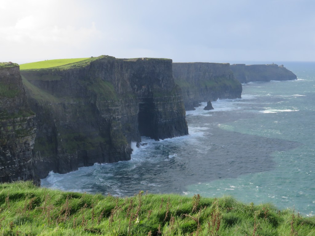
The Cliffs of Moher rank at number 4 in the top ten things to see in Ireland, according to our guide book, so despite them being sixty miles away, we had booked for the ‘experience’. Together with the Burren nearby, the cliffs are a UNESCO Global Geopark; an area with outstanding geology and local culture. The cliffs are 200 metres high with the crashing Atlantic below. The flagstones found on the cliffs were quarried in the nineteenth century and many are now paving English streets. Five hundred men were once employed in this industry but it was made redundant by the invention of concrete. The name comes from ‘Mothar’, meaning ruined fort; there was an Iron Age fort on the site. Storms led Spanish Armada ships to be wrecked along this coastline. Around the bottom of the cliffs are various spots that are allegedly where Spanish sailors were executed and buried. The tower at the highest point of the cliffs was built by Sir Cornelius O’Brien. It was intended as a viewing point for visitors. He also provided a piper to entertain them.
The weather was alternate sunny spells and squally showers, with high winds. We managed to walk to the top of the cliffs in the dry and the visibility was better than anticipated. There are quite a lot of steps but golf buggies were transporting those who couldn’t manage the walk. If you visit and think you might need one, do check out if they need to be booked in advance, there didn’t seem to be very many considering the number of people visiting.
The cliffs are allegedly home to buskers but they were not in evidence, perhaps deterred by the weather. Strong winds and salty air doesn’t do their instruments a lot of good, so these are either custom made to help withstand the conditions, or replaced frequently.
We went back to look round the visitors’ centre. We watched a slightly sick-inducing film of the bird life of the cliffs and the marine life below. This was projected across three screens at angles to each other. It was probably meant to be ‘immersive’ but it had a similar effect to being carried from room to room by someone on a Zoom call. There was the opportunity to have our photograph taken, superimposed on a Cliffs of Moher landscape by using a green screen. You could then email it to yourself. This involved ‘swiping right’ to find your own picture amongst everyone else’s. To me if photos are in a horizontal strip and it says ‘swipe right’ and there is even an arrow pointing to the right, you push them across in the same direction as you’d read a line of text. We failed to find our photo. My trusty companion insisted ‘swiping right was the opposite direction. My argument that that wasn’t right, or indeed correct, fell on stony ground when he located our picture. Good job I am not on Tinder, or should I worry why said companion knows how to ‘swipe right’? The resulting photo has us looking decidedly fuzzy and out of focus in front of a lovely background.
No one can blame Ireland for exploiting everything they’ve got to attract tourists but this was definitely a tourist honey-pot and you couldn’t escape the commercialisation and dozens of coaches in the carpark. A bit like the Giants’ Causeway and Land’s End, this is no longer the wild unspoilt landscape it should be. To be fair, the visitors’ centre has been built into the cliff in an effort to disguise it but I prefer more out of the way places, some of which, close to home, are equally spectacular. More than 1½ million people visit each year, compared to 100,000 in 1978; perhaps I should have visited in 1978! You’d think therefore that there might have been a few more toilets, larger café facilities and more pay stations in the gift shop. Given that the height of the tourist season has passed, the queues were ridiculous.
We debated heading up the cliffs in the opposite direction but at this point it decided to rain a little more aggressively, so we headed back to the car. We have finished The Story of England and have now embarked on Tales from the Green Valley, the seventeenth century prequal to Victorian Farm.
Despite the forecast for 70% or more chance of rain all day every day for the next eight days and an early shower, we left Carrowkeel to a cloudless sky. We opted to avoid the toll charge on our drive south to Adare. It isn’t that we are pathologically adverse to paying toll charges, it is just that this often has to be done online and we weren’t sure that we would have access to online. By now we have got the hang of the pulling over and travelling on the hard shoulder to let faster traffic pass, which is how things are done in Ireland. We are limited to 80kph when the caravan is on the back. I spend our travelling time translating the kph to mph, which fortunately our satnav does, even if the car is unhelpful in this respect. We drove through Galway and Clare to arrive in another new county, Limerick.
In theory there is only wifi at reception at this site. When choosing our pitch, I opted for one as near as possible to reception. My travelling companion is less keen, ‘we will get all the passing site traffic’, says he. ‘Oh’, I say , innocently, ‘but look it is lovely and sunny and has its own picnic bench.’ Yes, it does also have one teeny tiny bar of wifi from within the caravan, enough to download emails at least. Not that that was a consideration of course!!! It did prove useful as we hadn’t been able to book a site for our last five nights, when we wanted to be in Cork or Waterford. Sites we tried were either closed by the end of our stay, only took camper vans not caravans, or were no longer operating. That teeny tiny bar of wifi enabled us to find somewhere for the final leg of our trip. Slightly longer stays for our last three stops and it feels like we are on the downhill slope now, as indeed we are. The site also provides us with breakfast blackberries.
Day 21
With the forecast rain more in evidence, we retraced our journey from yesterday a short way to visit Bunratty Castle and Folk Park. Fortunately, by the time we arrived, the rain had virtually stopped and we manage the tour without getting soaked.
The site began as a Viking trading post and then a wooden fortification was built at Bunratty, overlooking the river Shannon, in 1251 by Norman, Robert de Muscegros. A stone castle was built in 1277 by Thomas de Clare and the present building was erected in 1425 by the MacNamaras and was later taken over by the O’Briens, who were to become Earls of Thomond. It has been much altered since and was seriously damaged by troops fighting with Oliver Cromwell and later William III. The castle and land passed to Plantation families and had been abandoned by 1800 until it underwent significant restoration in the 1950s, by which time it was little more than a shell. You’d kind of think that if you’d seen one castle you’d have seen them all but there is something a bit different about Bunratty. There is a huge contrast between the large central rooms, including 10,000 year old Irish Elk antlers retrieved from a bog, some very odd light fittings, that are apparently called leuchterweibchen and are German in origin and the tiny rooms in the towers, which are accessed up some fairly perilous, narrow spiral staircases. Definitely not recommended for those with mobility problems and I did wonder how many visitors had to be rescued having got stuck somewhere in the warren-like one-way system.
In the 1960s, improvements to aircraft, meant that refuelling stops at Shannon airport were no longer necessary and an active campaign to attract foreign tourists to the area began. Much of this revolved round medieval banquets at the recently restored Bunratty Castle, which were offered to visitors for free, along with a coach tour and overnight accommodation to anyone who stopped over at Shannon airport. The banquets continue, although are no longer free and many celebrities have attended over the decades.
The castle is now part of a folk park, with reconstructed Irish dwellings. We’ve been to a few of these now and a bit like castles, you’d think it would be seen one, seen ’em all but we are not yet Folk Parked out and each one offers something slightly different. Here at Bunratty there were farm animals to see and a few costumed characters including a loquacious blacksmith telling tales of the little folk. There was also a shopping street, where some of the shops were also doing duty as retail outlets for crafts people. The last building of the tour was the tea rooms where I opted for an enormous slice of coffee cake. It is very rare for me to be beaten by such things but delicious though it was, I did admit defeat. I couldn’t even offer it to my companion as he is allergic to coffee.
Where to start with the story of our visit to Strokestown? There was so much to take in. As per the weather forecast, there was mist and drizzle as we headed eastward along the N5 to Strokestown, taking us into a new county, Roscommon. This is the home of the Famine Museum and as such tells the story of a significant part of Ireland’s history and also the blameworthy role of the English. This is definitely somewhere that should be on the itinerary of anyone touring Ireland. We arrived just after it opened and were disappointed to see that the house tours were fully booked by coach parties but it was the museum we were most interested in. In general, I am not a fan of audio guides but you definitely need one to get the full benefit of the experience. This is the third iteration of the museum, which was established in 1994; this version was only opened last year. It is excellent, telling the harrowing story in an evocative and informative way. When Jim Callery purchased the estate in 1979, from the Mahon family, who had owned it for three centuries, he discovered 55,000 documents, recording the full extent of the Mahon’s occupancy and being particularly informative about the famine years. One of the documents at Strokestown was the 1846 Cloonahee petition, signed by starving peasants begging for work and seeking action from the Strokestown District Relief Committee.
There was a significant population rise in Ireland between the 1740s and 1840s, with Roscommon seeing a 300% increase, putting a strain on resources, even before the famine took hold. By 1847, there were approximately 12,000 people living on the Strokestown estate. There was a strict hierarchical system, with Protestant ‘Ascendancy’ families owning more than 70% of the land in Ireland. Middlemen rented large tracts of land from the landowners, then sub-let to cottiers at inflated prices, with leases that gave the cottiers few rights and many were unable to pay their rents. In 1845, about a third of the population were cottiers. Spalpeens or labourers worked for the farmers, in return for the chance to grow potatoes. A labourer would eat 14lb of potatoes a day, making up 90% of his calorific intake. Most of these were Lumper potatoes, a high yielding variety but susceptible to blight. Such reliance on a single crop made it all the more catastrophic when it failed. There were failures of the potato crop across Europe at this time but the impact was softened by the availability of other crops.
The Great Hunger of the 1840s led to one million deaths and two million emigrations from Ireland, at a time when the total population was under nine million. Major Denis Mahon inherited the Strokestown estate in 1845, by which time it was £30,000 in debt. This was not unusual and many landowning families were in a similar situation. Denis Mahon did provide relief for his tenants , in the form of weekly doles of corn, this cost them a penny a pound, or in some cases was freely given. Nationwide, over three million people a month received relief in the summer of 1847. The landowners were not happy about the cost of relief; some refused to pay the poor rates, leaving workhouses without funds. The British government felt that free doles made the peasantry lazy, so road building or ditch digging was expected in return for relief. Many of the poverty stricken were too weak to undergo this work, leaving the over-full workhouses as the only option. Aided by his land agent, John Ross Mahon (no relation), Denis Mahon instigated a mass emigration scheme, as this was cheaper than keeping people in the workhouse. The least productive tenants were those who were given assisted passages.
In summer 1847, 1490 emigrants left from the 32 townlands that formed part of the Strokestown estate. The heads of household are all named outside the museum. This is very much a theme of the museum, with many individuals commemorated by name and their stories told, or words recalled. Despite Denis suggesting that they depart from Sligo, John Ross Mahon arranged for the emigrants to walk to Dublin, more than 100 miles away, then leave from there, via Liverpool. The walking route is alongside a canal. Assuming the canal was built then, why were they not allowed to travel that way? A memorial trail, The National Famine Way, now marks their route. The emigrants left on four vessels for Grosse Ile in what is now Canada, as this was cheaper than America. Half of the emigrants died on the journey or whilst in quarantine.
Secret societies, such as the Molly Malones, aimed to disrupt the system of rent, taxation and the payment of tithes. Denis Mahon was murdered in November 1847, allegedly by members of the Molly Malones. The Museum gave a very balanced picture, showing Denis as someone who did try to help his tenants to a certain extent, whilst, at the same time, he was condoning John Ross Mahon’s mass evictions. The family went to extreme lengths to get tenants to give evidence regarding the murder. Those who did so were given free passage to Canada, those who refused were refused relief or evicted. Three men were hung and one imprisoned for the crime; the alleged ring leader was last heard of in Canada but was never caught. Denis’ English son-in-law, Henry Packenham Mahon inherited Strokestown and evicted many tenants.
We hit the 30% no rain window as we finished looking round the museum, so walked round the large walled garden. Unlike the museum, which was very impressive in many ways, the garden has been sadly neglected. We also followed the Woodland Walk. As we returned to the complex, looking for refreshment, we saw that there were spaces on the 2pm house tour, so decided it was worth a leisurely refreshment break and an hour’s wait. We paid the extra few euros to take the house tour and did another quick tour of the museum while we waited. We were very glad we were able to see the house as well.
Our young and enthusiastic house guide, John, was typical of guides we’ve had elsewhere and told a lively story of Strokestown Park House and the Mahon family. I sensed a definite ‘atmosphere’ in the downstairs of the house, although we were told no ghost stories. A young American visitor also remarked how cold it was. Nicholas Mahon was born in the south of Ireland and was a mercenary solider. He was given land at Strokestown for his support of the Cromwellian plantations of Protestant English in Catholic Ireland. He rebuilt the house in 1696. It is a Palladian style edifice with seventy three rooms, designed to portray wealth and status. Later generations of the family were better at spending money than acquiring it and there were insufficient funds to support the lavish lifestyle. Maurice Mahon the first undertook several expensive building projects, including rebuilding most of Strokestown to try, unsuccessfully, to create the widest street in Europe. We did notice on our way in how ridiculously wide the main street was. Another innovation was a tunnel between the stables and servants’ quarters, so scurrying servants wouldn’t mar the view from the windows.
The last Mahon in residence was Olive Packenham Mahon, who struggled to maintain the estate. She began by selling off art work and replacing it with reproductions. When she could no longer afford reproductions she made excuses for the gaps on the walls. Latterly, she tried to run the house with just two servants and was reduced to living in one or two rooms. The old-fashioned kitchen was unworkable and plans were made for the installation of a smaller, modern kitchen. Fortunately, the old kitchen was not removed but was boxed in, with a smaller kitchen being constructed within it, thus preserving the original range and other features, which were later rediscovered. Unusually, the kitchen had a gallery, from which the lady of the house could observe the servants at work. When the property was sold, it was on the condition that Olive could live out the rest of her life there. Most of her furniture and artefacts passed to the new owner when she moved to a nursing home for the last months of her life. This meant that almost everything in the house was original to the building. Sadly, it seemed that those on coach tours had been encouraged to prioritise the house. This is definitely worth seeing and we were very glad we waited to do so but this meant that most tourists were doing a quick wander through the museum, without an audio guide and missing so much of its significance.
Just a short episode this time as day 19 needs a post to itself.
With the weather forecast predicting 70% chance of rain all day every day for the following week and there being, the forecast claimed, just one more day of decent weather, we tweaked the itinerary slightly. First a visit to the nearby National Museum of Country Life, which was set up to complement the Dublin museums. Entry is free although donations are encouraged. Here, in this C21st building next to Turlough Park House, the emphasis is on the story of the people of rural Ireland. The contrast between the romanticised rural idyll and the reality of grinding hard work was emphasised. Many crafts were featured and it was brought home just how many skills have been lost. We began with a video presentation, then looked at the exhibits. Information about Curragh making and using heather bushes to make lobster pots went down well with the fisherman of my acquaintance. I was fascinated by the folk traditions, such as the straw boys, which have associations with mummers plays. Wearing conical hats that rest on the shoulders, obscuring their faces, the straw boys appeared at celebrations and parties. My one criticism of the museum was that many of the artefacts were unlabelled, so you were left thinking, ‘that looks interesting, what is it?’
After a shopping trip, we drove to Connemara National Park. We passed the fisheries at Killary, one of Ireland’s three fiords. One who knows identified that mussels were being farmed. The beautiful mountain scenery was different again, much greener and with little heather. The narrow roads, complete with potholes, were reminiscent of home. We looked round the exhibitions in the visitors’ centre, which explained the formation and importance of the bogs and the adverse impact of acid rain. A short stroll round the park and it was time to return to the van.
Ah ha! – you thought that was it didn’t you but no, I have more to come.
Day 15
After shopping for supplies and diesel, we left Northern Ireland and headed West back to the Republic. Our destination was Killybegs Holiday Park and we only had an imprecise address. The sat-nav recognises most campsites as a point of interest but not this one. There was also a lack of helpful signage. We got a little diverted round some hairpin bends in Killybegs before finally spotting a sign and heading up through what seemed to be an industrial estate. We arrived in pouring rain. This is a remote, terraced site and certainly the quietest we’ve been on. The guide book describes Donegal as ‘bleakly beautiful’ and that seems to be pretty accurate. There was a clear view of the Atlantic Ocean and lighthouse from the van, when you could see through the driving rain that is. We had a quick drive into Killybegs so the fisherman of my acquaintance could view the boats.
Day 16
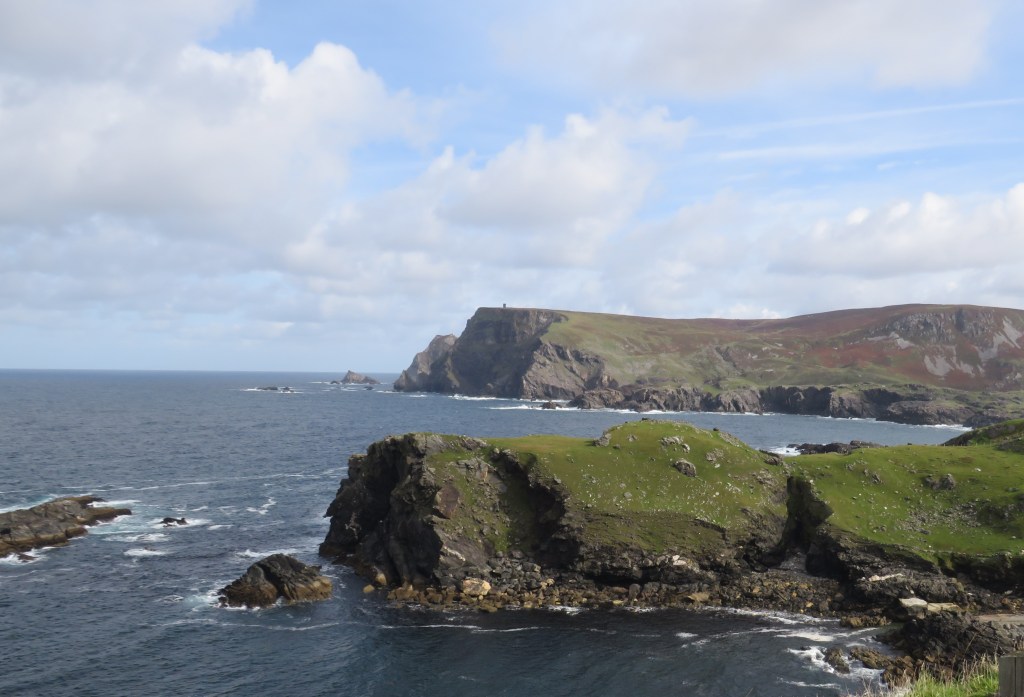
After a wild, wet and windy night, the sun shone and we drove along the Wild Atlantic Way through the Slieve League Mountains. This is the area that many tourists miss and there were very few vehicles on what was, for much of the way, single track road. The scenery was rugged and dramatic, combining the rocky Atlantic coast with the mountains. There were signs of peat cutting, wild fuchsia in many hedges and several abandoned dwellings, some looking like they had been left derelict more recently than others. We came across the Glencolmcille Folk Museum and stopped to look round. This was very different from the slick, government supported museums we had already visited but certainly worth a look. It paid tribute to the local priest, Father James McDyer, who did much to try to preserve the community spirit and provide a sound economic basis for the inhabitants of Glencolmcille from his arrival in the 1950s. He lamented the negative impact that emigration had had on the area and was instrumental in instigating the building of homes, bringing electricity to the community and establishing a knitting collective to supplement family incomes.
The Folk Park was founded by Father James in 1967. There were seven buildings to look round, illustrating typical Irish cottage life from the 1700s to the mid-nineteenth century. The roofs were made from a layer of bog timber, a layer of scraw, which is the top layer of the bog and then straw. The thatch is roped on and tied to stones that protrude from the walls. The cottages had St. Brigid’s crosses, made from straw, over the door. These were made each 31st January and were to protect the house from storms, fire and evil. We stopped at the Park for refreshment. The ‘Breakfast Baps’ were road-tested and given the seal of approval by Chris. They contained not just bacon but a fried egg and sausage as well.
We went the long way back to the site, driving up into the mountains as far as Doocharry.
We discovered after we’d had it for about five years that the television we use in the caravan played DVDs. We have very few DVDs but it turned out that I had put some in the van when we made the discovery about the television, in case we might watch them. One of these is Fisherman’s Friends, which we’d already watched on real TV this holiday. So, in the absence of a television signal and in complete ignorance of how to actually make the DVD player work, we settled down to watch part of Michael Wood’s story of England, based on Kibworth, which has an enviable set of documents. Talk about the perfect one-place study. There is three hours worth of this series on each DVD. Not wanting to watch it all, we managed to work out how to pause it, hoping we aren’t back at the beginning again when we come to watch the next installment
Day 17
We left our sea view behind at Killybegs and travelled through Leitrim and Sligo to County Mayo. This took us through Yates country and past the strangely shaped Benbulben, which is, says Google, a flat-topped nunatak rock formation. Any the wiser? No, me neither. On this site our choice of pitch was dictated by which one allowed us wifi in the van.
And there’s more – you are still a long way behind!
A proper day of mist and mellow fruitfulness as we set off early, with the thermometer reading six degrees, a whopping thirty degrees less than it did four days ago. The drive took us across the Sperrin Mountains, along the length of the scenic route that we failed to find on the previous day. We remarked on the trend for ostentatious gateposts that seem common on even quite modest dwellings.
After a lovely drive, we arrived at the Ulster American Folk Park. This should definitely be on everyone’s itinerary. It consists of period houses, almost all of which have been re-erected having been transported from elsewhere, including some from the States. These are used to tell the story of the widescale Irish emigration to the United States and Canada in a graphic and accessible way.
Although we think of mass emigration taking place in the famine years, prior to that, between 1815 and 1845, 1 million people left Ireland for North America, 400,000 of them from the counties that now make up Northern Ireland. A further million left during the famine years 1845-1851, over 300,000 from Ulster. In the eighteenth century, linen production was an important part of the Irish economy. Competition from American imported cotton, impacted on the linen producers and was an impetus for emigration. Agrarian unrest and the slump in the demand for Irish linen, led to 30,000 emigrants leaving Ulster in the 1770s, beginning chains of migration. Strangely, the main ports of departure were not on the west coast but the north and east, with ships leaving from Belfast, Newry, Derry, Portrush and even Dublin. By the 1820s, most Irish emigrants travelled first to Liverpool and then left from there.
The experience began with an indoor exhibition, focussing on the stories of real female emigrants, then we moved to the park. The whole site was very carefully arranged so you passed through the ‘Old World’, with typical Irish buildings first. Some of the buildings were inhabited by costumed guides who explained the history of the building and told the story of the emigrants who lived in that house. Only the Irish home of the Mellon family is in its original location. It is hard to imagine the logistics involved in dismantling and re-building the others. You then passed down the shopping street in an Ulster port and boarded the emigrant ship, where conditions were cramped and food poor. Those leaving during the famine were usually malnourished and/or sick before they embarked. In 1847, 20,000 Irish emigrants died on the journey. Leaving the ship, you find yourself in the ‘New World’, where the buildings have all been transported from America and include the American homes of the families whose Irish dwellings are also on the site. Pumpkin, sweet corn and tobacco are all being grown on the New World side of the park.
There is a commitment to working towards also telling the story of the enslaved and First Nations people and the exploitation that was a result of mass emigration from Europe. We couldn’t help thinking of the hundreds of tourists at Giant’s Causeway and feeling that they should all be here too but visitors at the park seemed to be few in number, which was a great shame and their loss.
We had a leisurely start to ensure that we didn’t arrive at the new site, a hundred miles or so to the north, before check in time. This saw us skirting Belfast, passing a sculpture called The Rise aka ‘The Balls on the Falls’. The journey was lengthened by lanes being blocked by broken down vehicles and accidents but we arrived safely and settled on to our pitch. The River Bann is behind us but the pitch is slightly marred by being opposite the toilet block/café, so rather busier than we’d like.
A visit to a nearby supermarket to collect supplies followed.
Day 12
Not quite such an early start but, taking into account past journeys, we allowed plenty of time to reach the Giant’s Causeway, so we didn’t miss our allocated entry slot and this time we were early. Our tour guide was Mark, another wonderful raconteur, who managed to successfully walk backwards for part of the route, so he was facing us, without bumping in to the many tourists. The Causeway gets tourists from 175 different countries each year and had nearly a million visitors a year pre-Covid.
The formation of the causeway, another World Heritage Site (two in three days), began 65 million years ago, when the tectonic plates drifted apart and lava bubbled up through the fissures and solidified. Further volcanic activity over millennia created the causeway. There are over 40,000 basalt columns and contrary to common belief, only about half are hexagonal. The others are mostly pentagons and septagons but they range from triangles to one single nonagon, whose location is secret. There used to be another 20,000 columns but these were quarried in the years before the site was protected. Tourists first became aware of the site when it was written about in 1692. In 1739, Susanna Drury painted a series of pictures of the causeway, which won a competition and this greatly increased the interest in the site.
The site is also home to various flora and fauna, including the narrow-mouthed whorl snail, which is unique to only three places and is the size of a grain of sand. The population has to be counted annually. This is done by sampling metre squares. Here you can find fulmars, oyster catchers, otters and stoats. Our haul was a heron and some female eider ducks.
Kelp is farmed in the area but 300 years of salmon fishing declined with the fish stocks and the last commercial salmon fisherman gave up in 2002, by which time the annual catch was about 300 fish a year; this had once been the daily catch.
We were treated to some ‘imaginative’ legends of the giant Finn McCool, credited with forming the causeway. We saw the rock formations known as Humphrey the camel, Finn’s boot, the organ pipes and the chimneys. After Mark left us, we continued to walk round to the next bay before returning to scramble across the causeway itself. There are three causeways of different sizes. I was a bit doubtful of my ability to rock climb safely; varifocals make this sort of thing difficult, so I was pleased to accomplish this without incident but definitely not recommended for those with mobility problems.
After leaving the Causeway we drive round the coast a short way to Portrush before returning to the van.
Day 13
We drove out to look at Lough Neagh. This is not held out to be much of a tourist attraction but we felt we should see the largest lake in the United Kingdom and in the island of Ireland. We viewed it from the west. It is a lake. It is large. That’s about it really. We later learned of the serious pollution problems in the Lough. There are issues with blue-green algae but additional pollution has put it in danger of becoming a dead lake.
We then headed for the Sperrin Mountains, designated as an Area of Outstanding Natural Beauty. We did find our way to the edges of them; yes, beautiful, if not outstanding. Then the sat-nav slightly let us down. We were supposed to end up at a visitors’ centre in the Sperrin Mountains. Owing, we think, to the fact that Ireland seems to have many duplicate place names we ended up driving through the outskirts of Derry, that we were trying to avoid and in the middle of a housing estate. The next plan was to head to a National Trust property on the coast. Again this did not go well. We did have a pleasant drive along the Causeway Coast Road but the only National Trust property wasn’t quite where the sat-nav said it would be and was closed. We decided to call it a day. On the plus side, it was finally a little cooler and less humid, with a few showers.