An early start and back to John O’Groats to catch the ferry for our ‘Maxi Tour’ of the Orkneys. We pass the entrance to the Castle of Mey, which, until 1996, belonged to the Queen mother. Three ewes and five lambs are running loose in the road. We do need to be in time for the ferry but we look to see if there is a handy farmhouse where we can report the escaped sheep. The only nearby buildings seem to be derelict so we have to hope the sheep will find their own way home.
We board the Pentland Venture to cross the eight miles of the Pentland Firth that separate mainland Scotland from South Ronaldsay, the most southerly Orkney Island that we will visit. We rashly decide that we are hardy enough to sit outside. I have listened to Jay Wynne who has told me it will rain, so when he is proved correct, I can wear my rain poncho, which today is a delicate shade of blue. It does turn out that I was confusing an arm hole with the gap for my head (I thought it was a bit small) but it did keep me dry and helped to keep out the piercing wind. I am a bit disappointed that there is no commentary. The vessel begins rolling interestingly and there is a penetrating smell of diesel. I begin to mentally assess if I have a suitable receptacle about my person should I be unpleasantly unwell. I don’t. Fortunately this is not required. We see gannets and guillimots before arriving at Burwick on South Ronaldsay.
We are collected by our guide, Stuart and set off on our coach for an eighty mile trip round five islands (South Ronaldsay, Burray, Glimpse Holm, Lamb Holm and Mainland). I am not disappointed about the commentary on this part of our trip. So today’s information is courtesy of Stuart, if he was stringing a line for gullible tourists then you may as well ignore what follows. Stuart tells us that a highest temperature of 12 degrees is forecast and there is a 50% chance of a hurricane. That last bit might be a joke, of which he has a repertoire. Orkney is on the same latitude (59 degrees north) as St. Petersburg and Churchill in Canada, the latter being famous for its polar bears. Today is apparently ‘quite mild’, I’m so glad he mentioned that. There is actually very little snow or frost on Orkney, with average temperatures ranging from 5 degrees in winter to 15 degrees in summer. The average sea temperature is 11 degrees. There is plenty of rain and we are experiencing some of it. There are frequent high winds, with 137 mph being the highest wind speed recorded. Day length is 21 hours in summer and 5½ hours in mid-winter and I have noticed at Dunnet Bay that it is getting light by 4am and not getting dark until 10.30pm. There are very few trees on Orkney, thanks to the twin forces of man and the weather. Primary school children are taken on trips to walk in a small copse that has been conserved, as it is such an unusual experience.
Until 1468 Orkney belonged to Norway and came under the rule of the King of Demark. When Margaret, Princess of Denmark, was to marry James III of Scotland, she was meant to have a dowry of 60,000 florins. 50,000 of these remained unpaid and the Orkneys were ‘loaned’ to Scotland as security until the remainder was handed over. Later Shetland was added to this ‘mortgage’. When the money was not forthcoming, the islands were forfeited to Scotland. Orkney is now one of Scotland’s counties. The politics here are Liberal Democrat, a legacy from the time when Liberal leader, Joe Grimond was the MP and lived on Orkney. There is only a 2% unemployment rate on Orkney. The islands boast the shortest charter flight in the world, of two minutes between two of the islands. Kirwall’s airport is classed as an international airport, as summer flights go to Bergen.
We drive alongside Scapa Flow, 120 square metres of natural harbour, which measures 65 metres at its deepest point. In the world wars it housed the entire British home fleet. During World War I, the four channels between Scapa Flow and the North Sea were blocked by sinking ‘block ships’ in the gaps, to prevent the intrusion of U-boats. These ships gradually shifted, allowing, in World War II, a U-boat to enter and sink the Royal Oak. The majority of the fleet had already left Scapa Flow, or the damage would have been much worse. Churchill ordered that more permanent barricades should be constructed and what are now known as the Churchill Barriers were constructed by Italian prisoners of war. Prisoners of war were not supposed to work on anything that would help the war effort, so these barriers were billed as causeways to help the residents. After the war, local fisherman wanted them removed as they stopped their access to the North Sea but they remained, to the detriment of the fishing industry. Signs of the old blockships are still visible. The new barricades consist of 60,000 concrete blocks resting on top of gabions. Most of the 1200 POWs who built them were former construction workers. The now redundant fishermen took up chicken farming, which worked well until 1952, when a hurricane literally blew most of the free range chickens away. Present day farming is predominantly animal husbandry, Aberdeen Angus beef cattle, there are 140,000 head of cattle on the islands, sheep and pigs. Barley is grown for animal feed and there are three grass crops a year for silage to use as winter feed. Scapa Flow is noted for being the site of the scuppering of the German fleet of 74 battleships in 1919, on the orders of the German Admiral, who did not want the interned ships to fall into the hands of the British. Most of the vessels were later re-floated and sent for scrap.
The current population of Orkney’s seventy islands, many of which are uninhabited, is 21,000. To put this into perspective, Stuart tells us that the area of Orkney, 370 square miles, is similar to that enclosed by the M25, where nine million people live. During the war approximately 60,000 servicemen descended Orkney. Not only was the home fleet in Scapa Flow but there were also army camps and four airfields. The main road was built by the Royal Engineers, replacing the former single track road. Now tourists swell the population and a new pier at Kirkwall enables 150 cruise liners a year to disgorge their passengers.
 Our first stop is the capital, Kirkwall. I am very excited to learn that St Magnus’ Cathedral is currently the site of the first Scottish exhibition of the ceramic poppies, that I narrowly missed at the Tower of London. The weeping wall of poppies is here to commemorate the 100th anniversary of the Battle of Jutland on 31 May. Aptly, two doves have nested in the poppies. The red sandstone cathedral was founded by Rognvald, nephew of Magnus Erlendsson in 1137. Magnus, Earl of Orkney, had been killed on the orders of his cousin and fellow earl, Hakon. In 1468 James III gave the cathedral to the people of Kirkwall. Post reformation the cathedral was used for Protestant worship and can now be used by any denomination. We also see the nearby Bishop’s and Earl’s palaces.
Next, we take a swift look round the museum. A plaque tells us that the museum is housed in Tankerness House, which was the manse for the archdeacon and choirmaster of St Magnus’. After the Reformation it was acquired by Kirkwall’s first Protestant priest, Gilbert Foulzie. It was for three hundred years the town home of the Baikies of Tankerness. I make a fruitless foray to shops in search of an Orkney sew-on badge that I like to collect from places I visit. Instead, I invest in a Christmas decoration that is inscribed ‘Orkney’, as I also like to bring these back as souvenirs.
We drive across the RSPB Hobbister conservation area. About 180 species of bird can be seen on Orkney at different times of year. There are many raptors including sea eagles that have recently returned after long absence. We see curlew and eider ducks. Our second stop is a rainy Stromness, home of William Rae, who discovered the north-west passage. A group of goldwing bikes drive past and there are fishing boats to examine but there is not a great deal of potential in Stromness so we take Stuart’s advice and eat in the Ferry Inn.
 I have been really looking forward to visiting the Neolithic village at Skara Brae, especially after our own foray into the Neolithic era. The stone dwellings here are very different from our constructions at Old Sarum – different landscape, different building material available. The settlement is 5000 years old, older than the Pyramids, Stonehenge, the Parthenon and the Great Wall of China. It was hidden for centuries and rediscovered after a fierce storm in 1850. The life expectancy of those who lived here from c3100-2500 BC was thought to have been about 20. The trouble with this kind of trip is that three coach loads of tourists are deposited at attractions at the same time making photography difficult but we do our best. At least our party are prompt at returning to the coach at the designated time, perhaps persuaded by the rain.
As we move outside to Skara Brae there are stepping stones taking us back in time from the first man on the moon, through the Inca civilisation, to the time of the Pyramids. This is a great idea but it could do with a few more stones. Work is ongoing to try to discover more about the inhabitants of Skara Brae. It is thought that their roofs might have been made from seaweed. The stone dressers and bed boxes are fascinating. Interestingly, they couldn’t use peat as fuel as the peat here is only 3000 years old. Nearby is Skaill House, built for bishop of Orkney on top of a Pictish graveyard. We don’t have time to look at this and the rain is getting heavy so we return to the coach.
By the time we reach the Ring of Brodgar it is very wet and the impact of the concentration of tourists is at its greatest here. The ring is 104 metres in diameter and originally contained 60 stones, of which 27 remain. Like Skara Brae, it was erected about 5000 years ago. The stone for this, the third largest stone circle in Britain, came from a site nine miles away. We pass other prehistoric sites including the Ness of Brodgar, a 5300 year old burial mound and the oldest standing stones in Britain, the Standing Stones of Stenness. In the same area is Maeshowe, a large tomb of the same era, which is aligned so that the setting sun on the shortest day, illuminates the chamber.
Our final stop is at the Italian Church, constructed on Camp 60 from two plaster board lined Nissan huts by the Italian POWs. The beautiful internal decoration include tromp d’oile brickwork. Stuart tells us more of island life on our return to the ferry, through a sea ha. On Christmas Day and New Year’s Day the streets of Kirkwall become the pitch for ‘The Ba’, a massive game of football that might last up to five hours. I know this as Crampball. Orcadians, a little like the Cornish at the opposite British extremity, consider themselves to be a separate race. Don’t call an Orcadian a Scot any more than you’d call the Cornish English.
As we drive toward Burwick we are hatching plans to secure seats on the lower deck of the ferry but yet again the weather changes and the harbour is bathed in sunlight. On the strength of this we once again sit outside. The wind is biting but we persevere for the forty minute journey.
As the sun is shining and we have eaten a meal, we decide that this evening is the best time for our foray to the most northerly point of Britain, Dunnet Head. We brave the gales to take rather windswept looking photographs and then return to the van by which time it is raining again.
 On the way back to the van we call in at Currie, where my granddaughter’s ancestors came from but no luck with the graveyard here. There are some very unusual stones there though.
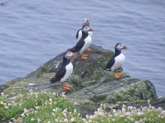 We start to see more and more seabirds through the mist and drizzle, including my first ever puffin! As we near the island the water is thick with guillimots, razorbills and more puffins. We have three hours to spend on the island and we walk most of the pathways. Departing from the marked routes is strictly forbidden in case puffin burrows are damaged. Even with my very basic £100 camera I manage half decent, recognisable shots of the islands birds. Apart from the puffins, razorbills and guillimots there are, oystercatchers, shags, fulmars, black-backed gulls (lesser and greater), fulmars and kittiwakes. There is also an active tern colony and the terns dive bomb the visitors making their strange ticking cries (that would be the terns’ cries, not the visitors). Eider duck nest right by the pathways; I had forgotten that the females were a drab brown, in contrast to their gaudy husbands. A tremendous plus for having had to do this part of the trip two years later than originally planned is that, had we made it here as intended in August 2014, there would have been far less to see. Despite the chilling wind I am having a great time, though I agree that slightly warmer weather would have been the icing on this particular cake.
 A great deal of what is known about sea birds and migrations patterns is thanks to data collected on May. Only the researchers live on the island as the lighthouse is now automated. It is 200 years old and was built to replace the oldest lighthouse in Britain, which was a coal fired beacon tower dating from 1636. This took between one and three tons of coal a night to maintain, all of which was brought from the mainland and hauled to the top of the tower. The island used to be a monastic foundation, with St Ethernan’s shrine attracting pilgrims since the seventh century. The island was home to St Adrian until he carelessly got murdered by the Vikings in 875. In 1500, James IV had a picnic on the island, because he could I guess. After the 1715 Jacobite rebellion, three hundred fleeing Jacobites somehow got stranded on May for eight days without food.
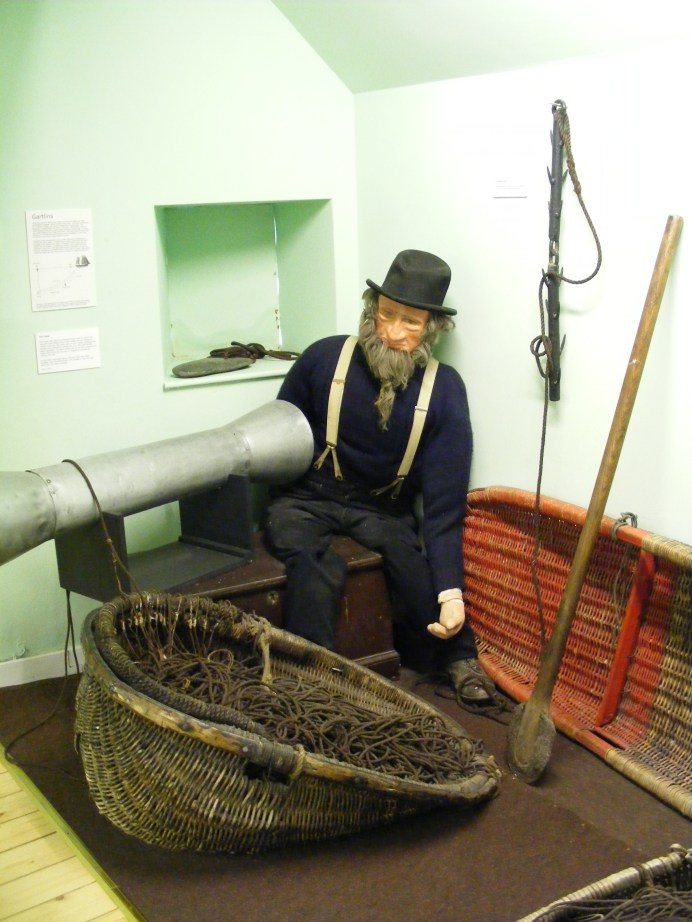 A nature reserve was on the itinerary for this afternoon but we are still in single digit temperatures, with biting winds and drizzle, so we think again. We decide to head for Anstruther to see where tomorrow’s boat trip starts. We drive along the Fife Coastal Tourist Route, through the East Neuk villages, past fields of potatoes and arrive at Anstruther. This areas was described as a fringe of gold by James II. ‘Neuk’ means corner and here we are on a small corner of the east coast. We spot some shell houses in Anstruther and then we find the harbour and enquire at the ferry office. Yesterday’s and today’s sailings have been cancelled due to bad weather, this does not bode well. It is definitely a day for an indoor activity so we look round the Scottish Fisheries Museum, which used to be home to some Braund family boats. We knew that these had moved to Eyemouth and we hope to see them in a few days’ time. The museum is very well done, part of it is housed in the former occasional lodgings of sixteenth century abbot of Balmerino. There is another strange toilet-related incident at the museum. These are very strange contraptions and I am initially at a loss as to how to effect a flush. There are tiny hand basins on top of the cisterns and turning on the tap also flushes the toilet.
 After about five minutes casting our eyes round stones with all the wrong names on and on the point of giving up. I locate Mr Sharp who should be next door to the Wight family. Yes, there is a flat stone nearby but compacted grass, the product of many mowings, is stuck firmly to its surface. I wish, too late, that I had taken a ‘before’ photograph. We begin rubbing away, being careful not to obliterate the sandstone surface at the same time. Grass has grown quite a long way over the edges of the stone, covering the inscription. I decide that we need a spade to remove this. We do not have a spade, how short sighted of us. Chris has his barber surgery kit in the boot ready for a conference at the end of our trip. I suggest using one of his many knives, saws or axes to hack back the grass; he seems less keen. We imperil our finger nails by hauling at the grass roots. As for the mowing detritus, in the end we perfect a technique of rubbing the soles of our shoes over the grass, which eventually loosens and can be swept away. This works better with my trainers as Chris has smooth soled shoes on. Well, that was his theory and he was sticking to it. It is quite a large stone and I am rubbing vigorously. If you are ever tempted to try this, be warned, it involves a lot more effort than you would think. The weather has meant that today is the first day we haven’t been for a walk but I decide that stone clearing constituted sufficient exercise. Ten minutes later and the stone is as clear as it is ever going to be and I am well pleased.
 for 12.15, along with many rabbits. This is my first internet access for four days and even this is only courtesy of Chris’ phone. Three hundred emails arrive on my computer, deep joy. Nothing features on our to do list for this afternoon. Our map indicates that there is a National Trust for Scotland property nearby so we head off to Leith Hall. Leith Hall itself, it turns out, is shut however we can follow the Kirkhill trail rounds the grounds and look at the gardens, which we do. A collapsed bridge means that the pond trail is impassable but we see a Dule Tree. This we learn is a large sycamore, allegedly used as a gallows. Dule is from the Gaelic for grief and sycamores on mounds may have been used as sites of mourning. Today is overcast and the wind is chilly but we complete our walk without getting rained on.
 ng that they might see bears at ‘Highland Bear Lodge’. Maybe highland bears are akin to yellow tits and indeed the Loch Ness monster. We drive through pretty birch woods to Glen Affric. There are more sheep in the road; these are sitting down contentedly as if they were in a field. There are deer relaxing nearby, maybe they have evicted the sheep. We pass the Fasnabyle HEP plant, reminding us how important the energy business is to Scotland. We head back towards Inverness by a different route, with the River Glass on the right and a bluebell wood on the left to enter the Black Isle, between the Moray Forth and Cromarty Firth. This peninsula, previously named Ardmeanach, was given to Lord Darnley by Mary Queen of Scots. The views are glorious. I find this one of the most attractive parts of Scotland, yet I was expecting to prefer the west coast.
 It is interesting to fully appreciate that Cumberland’s government red-coat army of 10,000 men would need 10,000lb meat and 10,000lb bread each day to sustain them. The lack of supplies for the Jacobite forces was a significant feature at Culloden, along with the boggy terrain which led to the failure of their previously successful charging technique. The battle lasted less than an hour and nearly half the 1500 Jacobite casualties fell in the few minutes of this failed charge. The government troops lost only 50 men, although some of the 250 wounded died later. The Irish and French, who were fighting for the Jacobites, shielded Bonnie Prince Charlie’s retreating army, who headed for Inverness after the battle. These Irish and French were subsequently treated as prisoners of war not rebels. The Jacobites did regroup at Ruthven and were prepared to fight on but Bonnie Prince Charlie sent orders to disperse and the cause was lost, leaving Charlie to escape ‘over the sea to Skye’ with the aid of Flora MacDonald.
 Our site at Dunnet Bay is exposed but right by the sea and we have a pitch that has what might be classed as ‘sea glimpses’. After setting up the van we depart for John O’Groats, well you have to don’t you? It isn’t quite as commercialised as Land’s End or Gretna Green and it seemed important to visit what claims to be the most north-easterly settlement in Britain. There are some weird multi-coloured wooden buildings, which are apparently extensions to a hotel. If they were trying to look like Balamorey they’ve failed. A little like Land’s End it isn’t actually the extremity that people would have you believe. Dunnet Head is the most northerly point and we plan to visit there before we leave. We are primarily in John O’Groats to pick up our tickets for tomorrow’s trip to Orkney and to see where we need to be first thing in the morning. That accomplished, we move on to Duncansby Head. We arrive in a fierce hail storm and decide to sit it out, hoping for a gap in the precipitation so we can visit the fulmar colonies that nest on the cliffs here. Yes, Scotland’s weather does it again and within ten minutes it is dry and we decide to risk it. The ground however is anything but dry and is best described as spongy. Chris has his walking boots; mine are in the van so I paddle along in trainers as far as Duncansby Stacks.
 Anyway not boats, gardens or ticks but an RSPB reserve. I don’t get much opportunity to utilise my RSPB life membership so I am not going to miss this one. Like Loch of Lowes there are nest cams on an Ospreys’ nest that has been in the same location for decades. The female, EJ, unimaginatively named for the letters on her leg ring, has been using it since 2003 and has gone through three partners in that time, producing twenty five chicks. The current male is Odin and both adults are on the nest most of the time we are there. This year’s brood have hatched, one five days ago and one at 4.30am this morning. The egg laying and therefore the hatching, is staggered to give at least one chick a chance of survival. Today’s chick still has its head in the egg shell. The staff continually monitor the nest to guard against vandals, poachers and egg collectors. There is great excitement as a third osprey flys overhead and Odin’s alarm calls are clearly heard. This reserve gets full marks for its nest cam, as the screen allows you to take clear photographs, although the nest itself is too far away for my camera. Their viewing window is in rather a dark corner, so my attempts at photographing siskins and greenfinches through glass are less successful than those through the viewing window at Loch of the Lowes.